
Still the two main headlines of today are the gusty winds and rain overnight.
Wind Advisory
A Wind Advisory will be in effect from 6pm today thru 6am Tuesday. Wind gusts up to 45 mph are possible. As of 4pm, BNA has already gusted up to 28 mph and winds will continue to howl. Secure outdoor furniture, trashcans, Christmas decorations, God’s frisbees, etc.
Also, with these gusty winds, any fire will spread quickly. Burning is prohibited in Davidson, and there is a burn ban in effect for Williamson.
Heavy Rain Overnight
We finally get some much needed rain. Although it won’t completely solve our drought, it will help.
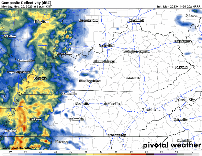
The HRRR model (above) shows:
- rain starting around 6-8pm
- heaviest rain ETA of 1-2am
- rain ending around daylight Tuesday morning, maybe a lingering shower or two during the day
There is no severe weather threat for us, that is all well to our south in Mississippi and Louisiana. You may hear a rumble of thunder or two overnight, but you are all good to roll to the other side of the pillow.
Expected rainfall totals are around 1″ – 1.5″.
Cooler and (Mostly) Dry Rest of the Week
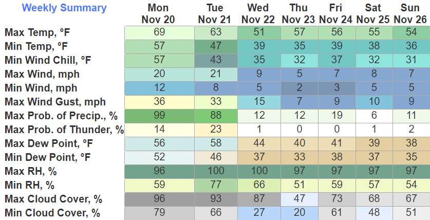
Cooler and drier air will filter in Wednesday and hang around for the rest of the week. Thanksgiving morning we will wake up around the freezing mark, although temps rebound well for the afternoon.
Maybe some light rain chances overnight Thursday, but models aren’t in too much agreement. If there is any, it would be light and NBD.
Black Friday shopping weather looks a-okay.
Quick References:
Weather changes constantly.
Follow @NashSevereWx on Twitter for any changes to this forecast.
Live coverage during tornado and severe thunderstorm warnings:

Look good.
Support the mission.

We are 100% community supported. No ads. No subscription fees. Keep it free for everyone.


Categories: Forecast Blogs (Legacy)
You must be logged in to post a comment.