
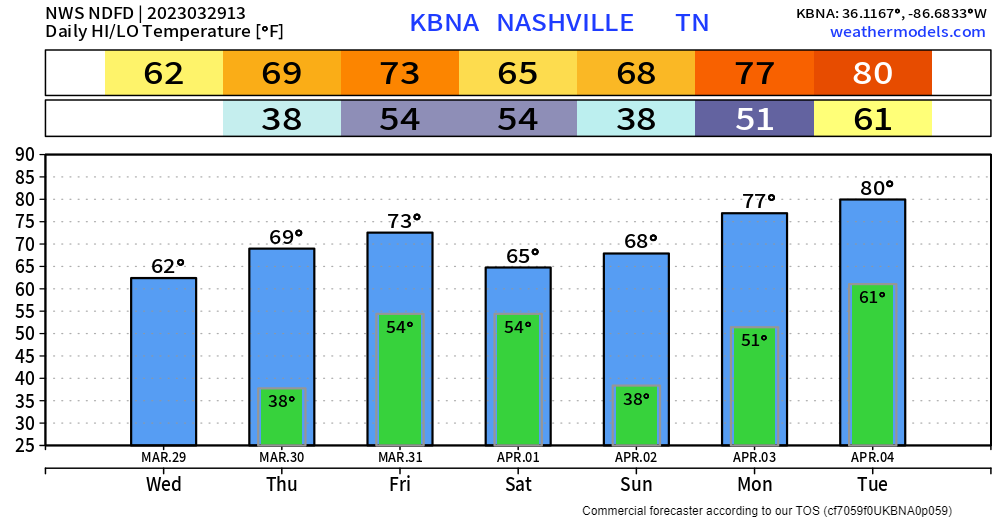
Waking up to cool temperatures, but they’ll quickly rebound into the low 60’s, making for a nice day. Tomorrow will be similar, except temps won’t be as cold in the mornings, and we’ll make our way to near 70°. Dry both days.
We are still outlooked for severe weather Friday.
West of I-65 there is a 30% chance within 25 miles, east of I-65, a 15% chance within 25 miles. Generally speaking, I think places in West TN and points further west have a better chance of severe weather than we do. Wind shear looks to be sufficient for severe weather, however we have a lot of other factors that say “Ehhh…this looks meh.”
- CAPE (storm fuel) looks real low
- Morning showers will help stabilize the atmosphere
- Although this seems counterintuitive, the atmosphere may be too moist for organized severe weather
No reason to write this threat off, a lot could (will) change between now and then, but so far signs are encouraging.
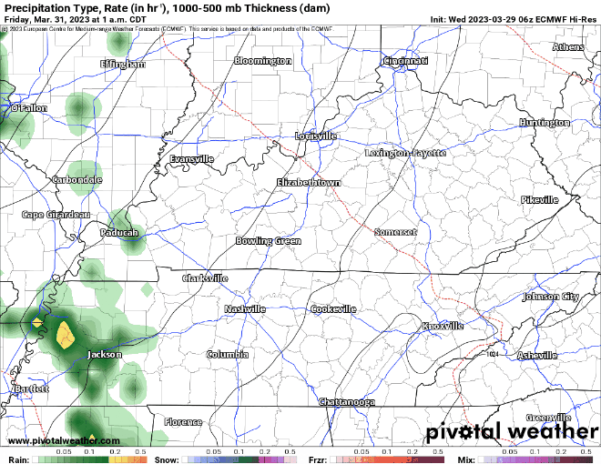
There EURO model, above, shows on/off showers all day before the line moves through Friday night. Wayyy too early to try to nail down a specific ETA, but a broad timeframe would be after dark.
Rain/storms will move out before sunrise Saturday, leaving us with a dry and warm rest of the weekend.
If you were hoping for a break from severe weather after this, you’re out of luck. Welcome to spring.
We are yet again outlooked with a 15% chance of severe weather within 25 miles on Tuesday. This is a ways away, and we have to get through Friday first, but we’re watching it.
Quick References:
Weather changes constantly.
Follow @NashSevereWx on Twitter for any changes to this forecast.
Live coverage during tornado and severe thunderstorm warnings:

Look good.
Support the mission.

We are 100% community supported. No ads. No subscription fees. Keep it free for everyone.


Categories: Forecast Blogs (Legacy)
You must be logged in to post a comment.