
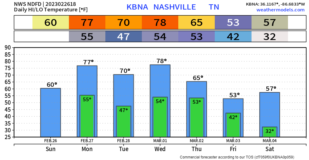
Rain has moved out from this morning, but clouds will stick around for the rest of the day.
Rain will creep back in Monday morning, not worried about severe weather, just some quick-hitting rain.
On Monday there is also a Wind Advisory from 6am – 6pm. Sustained winds of 20-25mph are expected with gusts up to 40mph possible. Batten down any outdoor furniture.
And if that wasn’t enough, the forecast high for Monday is 77°, the record is 78° set back in 1981, it’ll be close.
Tuesday is the day to get stuff done outdoors. Dry and warm.
The majority of Wednesday should be dry, with showers moving in later in the day. Another shot at breaking a daily high temperature record. Forecast calls for 78°, record is 81° set in 1997.
Thursday and Friday look soaking wet. 2-4″ of rain are possible, which could raise some river levels a bit. We’ll be watching.
For now, the bigger severe weather threat looks to be to our southwest. This is five days out, a lot will change.

Quick References:
Weather changes constantly.
Follow @NashSevereWx on Twitter for any changes to this forecast.
Live coverage during tornado and severe thunderstorm warnings.

Look good.
Support the mission.

We are 100% community supported. No ads. No subscription fees. Keep it free for everyone.


Categories: Forecast Blogs (Legacy)
You must be logged in to post a comment.