
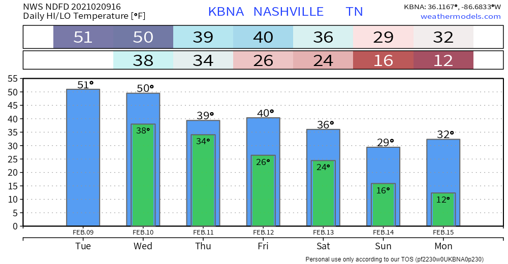
Not much happening today. Let’s talk about tomorrow and ice potential Thursday.
Cold Rain Wednesday/Wednesday Night
Showers will be light and off and on around midnight tonight and into the early morning hours Wednesday. Temps will be slightly too warm for any winter precipitation to occur.
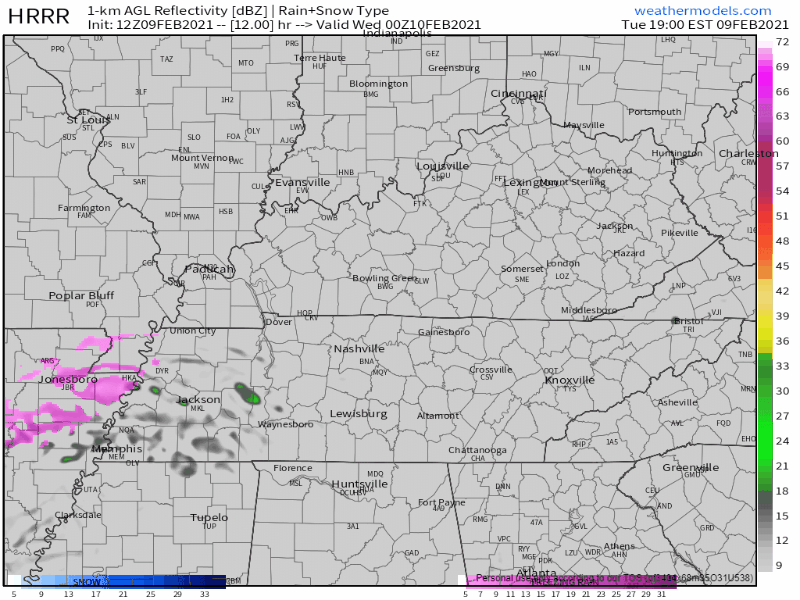
Light rain only Wednesday. That purple precip you see in the HRRR model above is where the HRRR model thinks surface temps will be at/below freezing, where ice may occur. For us, the ice threat is Thursday, most likely Thursday night.
A Refresher on Precipitation Types
We all know what rain is. Sleet is like that Sonic ice, when it hits your window it sounds like you have raccoons in your attic.

Freezing rain is what we’re concerned about. Freezing rain makes ice storms. Freezing rain is rain that hits the ground, then freezes. It freezes after it falls. It’s a sneak attack event because you’re driving through it and thinking “it’s just rain,” and it is, then it turns to ice and you end up in a ditch, or worse.
Heavy accumulations of ice can bring down trees and topple utility poles and communication towers. Ice can disrupt communications and power for days while utility companies repair extensive damage. Even small accumulations of ice can be extremely dangerous to motorists and pedestrians. Bridges and overpasses are particularly dangerous because they freeze before other surfaces.
NWS
Any amount of ice is a travel hazard, obviously. Power lines come down beginning around 0.25″ of ice, depending on the wind (the windier, the more impacts).
The current forecast for us only has some travel impact potential right now. Right now it does not look like a power grid outage event, but y’all, this event is close to us.
Cold Rain (Maybe Freezing Rain) Thursday
This will all depend on the surface temperatures.
Models seem to be agreeing on freezing rain to our northwest and cold rain for our area Thursday morning.
The Euro shows freezing rain just to our northwest at 6 am, but it thinks a freezing temps never make it into Nashville or Will Co. We’re just slightly too warm.
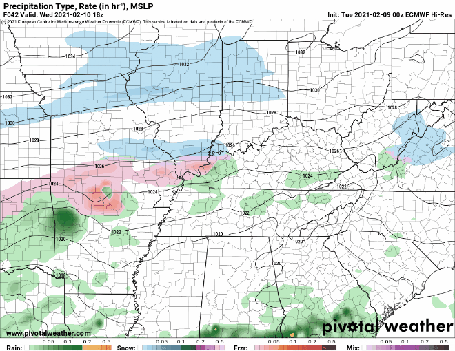
But the GFS model shows a horrible result for us, freezing rain Thursday by noon:
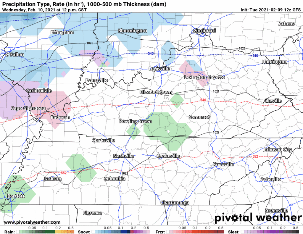
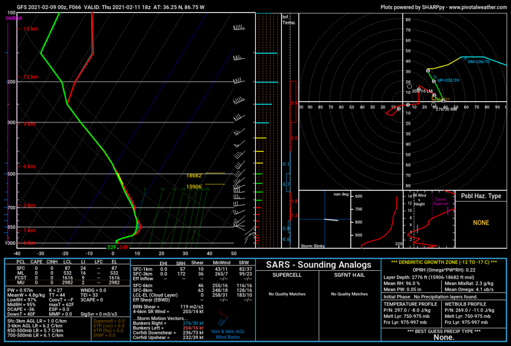
Freezing rain occurs when rain does not have enough time to freeze in the atmosphere, but will freeze when drops hit a below-freezing surface. Right now, temps are looking to be slightly too warm for this to occur, but it’s super close. Understand that many parts of Nashville and Will Co are at different elevations. The higher up you go, the colder it is, so we may have freezing rain and ice in Joelton, Fairview, and the hills in Will Co, but nowhere else. According to a sounding at noon from the GFS model, surface temps will be around 34° — that’s a BNA forecast not at a high elevation.
Precipitation should be out of the area late Thursday night; if rain lingers toward midnight, we may see more icing because it’ll be colder then, and temps overnight into Friday morning will hit a hard freeze for everyone. Wet roads will ice, especially bridges and overpasses.
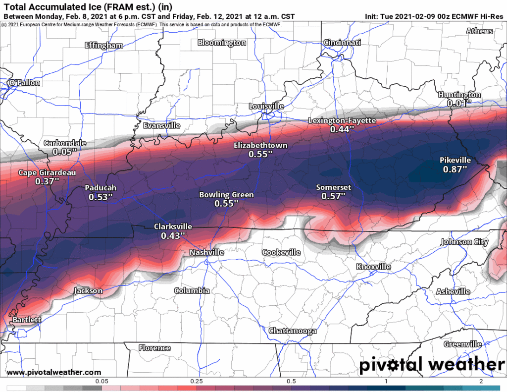
Note the ice accumulation models for Thursday night. We have, in one GIF, the Euro, GFS, NAM, and NBM. Look how close the high accumulated ice values are to us.
Editor’s Note: Many find snow fun. I’m one of them. But an ice event is as bad as our winter weather gets. Gas in the car is a good idea. If you have medications you need Thursday or Friday, get them now. I am not alarmed, but I am concerned. The risk is low, but threat to travel meaningful. Your Subaru or Big Truck Yeahhhhh cannot manage an icy road. The good news is high temps Friday afternoon should hit 40°, so any ice should melt.
Crank Up the Heaters
We’ll be drying out Friday and Saturday. A cold front is expected to go through Sunday.
After another cold front moves through Sunday, temps will be quite cold Sunday night, with lows in the single digits in the northwest and mid teens to the south.
NWS Area Forecast Discussion.
Categories: Forecast Blogs (Legacy)
You must be logged in to post a comment.