
Current Official Hourly Observation (taken at :53 on the hour)

Current Radar Loop
![]()
Temp & Rain Probabilities Next 36 Hours (auto-updating)
Today – Mostly Sunny, Slight Chance for Thunderstorms Late – High 91
Mostly sunny today. There’s a small chance of a shower popping up, but we think that’s unlikely.
Overnight, our eyes will be trained to the NW. A MCS (Mesoscale Convective System), fancyspeak for a cluster of storms, is forecast to develop over Missouri, Illinois and Indiana… Then possibly drift SE towards Middle Tennessee.
The HRRR’s Simulated Radar shows the MCS struggling to make it into Tennessee between 2 PM and 11 PM.
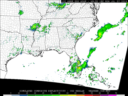
The NWS thinks that this MCS will stay N of us. There’s a small chance it’ll track further South. If it does, a weakened cluster of storms could clip Nashville early Tuesday morning.
The Storm Prediction Center is forecasting that Davidson and Williamson Counties just outside of the severe weather threat associated with the MCS:

Tuesday – Humid & Thunderstorms Likely – Wake Up 71, High 93
Once the MCS clears out, another one is expected to actually make it here late Tuesday afternoon/night, being helped along by a cold front.
The NAM Simulated Radar has the leading edge of these showers and thunderstorms in Nashville at 4 PM.

The Storm Prediction Center believes these storms may be severe:

The main threats will be gusty winds, hail and heavy rainfall. Localized flash flooding is also a concern.
Here’s a review of the hazard potential from our NWS:

Wednesday – Cloudy, Thunderstorms Likely – Wake Up 72, High 87
The slow-moving front will be to blame for showers and thunderstorms lingering into Wednesday morning, ending sometime Wednesday afternoon.
The NAM shows the line of thunderstorms past Davidson and Williamson Counties by 4 PM.

The SPC has not outlooked us for any severe weather after 7 AM Wednesday.
Extended Forecast:

This website supplements @NashSevereWx on Twitter.
Categories: Forecast Blogs (Legacy)
You must be logged in to post a comment.