
You may wonder, what in the world is a microburst? Sounds like not a big deal, right? “Micro.” But it’s anything but micro. It is a weather phenomena that produces tonnnnns of air that rushes from the cloud to the surface.
It’s like a giant cannister of compressed air getting sprayed straight down onto the earth from the downdraft part of a thunderstorm.
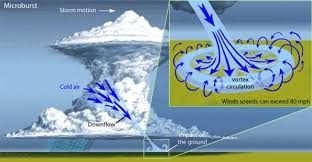
Downdrafts begin as all thunderstorms do. Warm air rises and condenses, creating enough clouds, and a thunderstorm forms. All thunderstorms produce downdrafts, but a microburst is a major downdraft.
Microbursts concentrate intense winds dropped from the sky, straight down, covering an area about 2.5 miles or less in diameter. They can produce wind speeds up to 150 miles per hour! Lots of people mistake microbursts for tornadoes. Microbursts can even have stronger winds than a tornado!! They can also look similar to a tornado from far away.

What you see in the picture is a microburst, all the precipitation getting carried from its winds, getting slammed to the surface of the Earth.
Where do mircrobursts occur? “Microbursts can occur all over the United States but are more common east of the Rocky Mountains, simply because there are more thunderstorms on this side,” states meteorologist Traci Pederson.
There are two types of microbursts: wet and dry. A wet microburst is when the precipitation reaches the ground. Dry microbursts are when the precipitation evaporates before it hits the ground, and all we get is the wind.
Microbursts happen most often in the spring and especially the summer.
If you’ve got horrible damage, don’t always assume it was tornado. It could have been a microburst.