
March 10, 2021
You may wonder, what in the world is a microburst? Sounds like not a big deal, right? “Micro.” But it’s anything but micro. It is a weather phenomena that produces tonnnnns of air that rushes from the cloud to the surface.
It’s like a giant cannister of compressed air getting sprayed straight down onto the earth from the downdraft part of a thunderstorm.
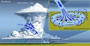
Downdrafts begin as all thunderstorms do. Warm air rises and condenses, creating enough clouds, and a thunderstorm forms. All thunderstorms produce downdrafts, but a microburst is a major downdraft.
Microbursts concentrate intense winds dropped from the sky, straight down, covering an area about 2.5 miles or less in diameter. They can produce wind speeds up to 150 miles per hour! Lots of people mistake microbursts for tornadoes. Microbursts can even have stronger winds than a tornado!! They can also look similar to a tornado from far away.

What you see in the picture is a microburst, all the precipitation getting carried from its winds, getting slammed to the surface of the Earth.
Where do mircrobursts occur? “Microbursts can occur all over the United States but are more common east of the Rocky Mountains, simply because there are more thunderstorms on this side,” states meteorologist Traci Pederson.
There are two types of microbursts: wet and dry. A wet microburst is when the precipitation reaches the ground. Dry microbursts are when the precipitation evaporates before it hits the ground, and all we get is the wind.
The dry microburst’s cloud base is higher.
Microbursts happen most often in the spring and especially the summer.
If you’ve got horrible damage, don’t always assume it was tornado. It could have been a microburst.
July 8, 2020
Derechos…Ever Heard Of It?
So let’s talk about what happened May 2. It was a Sunday afternoon. You remember it.
Did anyone feel like a tornado was ripping through your neighborhood? A lot of people might have thought this was the case. ERRR. It was not a tornado. It was a derecho.
Summer is derecho season.
Derecho
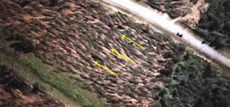
A derecho (“deh-REY-cho”) is a system of lined storms that has intense widespread damage from straight line winds and can produce heavy rainfall and or hail. The reason why I bolded widespread is because one difference between a tornado and a derecho is the damage from a tornado is in a more concentrated path.
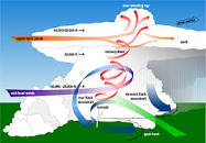
Have you ever wondered what causes straight line winds? Well, these winds are caused by a large downdraft from a thunderstorm. Thunderstorms violently hurl cool air from far up in the storm, down to earth (helped by gravity, of course). This “downdraft” slams into the ground. The wind has nowhere else to go, so it spreads across the ground the way a long sweeping broom cleans a gym floor.
Winds can get up to a whopping 100 mph!!! These straight line winds can cause power outages, knock down trees, and even damage buildings.
Derechos power themselves. The rain cooled downdraft winds push cold air ahead of the storm. New storms develop because of that cold air, along what we call a gust front. So the gust front allows the derecho to maintain its strength.
As the rain cooled air increases in size and broadens in the direction of the wind, an influence of inflow called the rear inflow jet or RIJ occurs on the trailing side of the system. This causes the updraft to tilt toward the back or rear side of the storm.
Eventually, the derecho dies. The “bow echo” structure collapses, or the derecho’s gust front encounters less instability.
Tornadoes
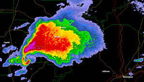
How are straight line winds different from tornadic winds? Tornadoes have rotating winds. Supercell tornadoes look like a “hook echo” on a radar. A hook echo is a radar signature shaped like a hook.
Sometimes tornadoes can form inside derechos, or other linear/non-supercell storms.
But the main difference between derechos and tornadoes is derechos produce widespread, long lived, straight line winds, whereas tornadoes produce more narrow, shorter-lived, rotating air with an intense updraft missing in derechos.
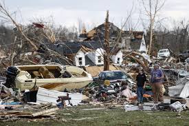
According to the Fujita scale (measures the strength of a tornado based on wind speed), tornado winds range from 65 mph (1 on Fujita scale) – 200 mph or greater (5 on the Fujita scale). They can cause devastating damage like the picture below.
Tornadoes are formed when warm, humid air rises and cool air wraps around the warm air. This causes rotation in the atmosphere.
Eventually, a wall cloud will form and the funnel will start forming.
Now, whats happening in the cloud is very interesting. The heat rises up in a circulating motion. Then there are mid level winds wrapping around the rising air then the air will eventually fall because it will begin to cool. This is called a rear flank downdraft. This is key to creating tornadoes.
When or if a derecho happens again in the Nashville area (I hope it does not), watch the radar and see if you can tell the difference.
February 22, 2020
When you wake up, what’s one of the first things you do before you decide what to wear? You ask Alexa or Siri, pull up an app, or watch local TV for the forecast.
You could just look at some plants and animals in your own backyard.
Nature is full of clues about approaching weather.
Plant Prophets
You should get a silver thistle. These flowers hate it when rain gets inside them, so they close their petals as a precautionary measure before it rains, to cover the interior of the flower.
You could also get daisies. Daisies close their petals or droop when rain is on the way to avoid a single raindrop from getting inside. This only works during the day though because daisies close up at night.

Animal forecasters
Animals are also forecasters.

The miniscule thrip, or thunderbug, has paddle-like wings. The thrip is so small and its wings are so tiny, flying through the air would be like you or me swimming. Warm and humid air is dense, making flying easy. So when these bugs are out, expect humid and wet air. It may explain all the ladybugs flying around your shower in the summer.
Same thing for mosquitoes. Like the thunderbug, then cannot handle the cool, drier air because their wings can’t move fast enough to stay airborne in that less dense air. They need the humidity!
Croaking frogs also provide a weather clue. During their mating season, at night, you can hear the males’ little hearts singing (croaking) to attract a mate. This tells us rain is on the way. The male frog loves the rain. Rain makes pools for their tadpoles to develop, so when they sense rain’s on the way, they start to sing.
Ever see a ring around the moon? That’s moonlight reflecting through ice crystal prisms in cirrus clouds high up in the sky. This usually means rain is on the way.
South wind and a darkening sky to the west? Uh oh, that’s probably a storm coming in.
In the summer, ever see puffy clouds getting taller, and taller, and taller? Rain’s about to fall out of them. After all, a rainstorm is a tall, heavy, cloud made of water. Pay special attention to this cloud.

sky is forced to rise.
That’s a pileus cloud, a cloud with a hat. The pileus clouds tells us the cumulonimbus cloud is rapidly growing and we can expect heavy precipitation.
Scientists don’t always need instruments or doppler radars to predict the weather and neither do you. Look at the sky, look at the flowers, observe the animals and all the things around you. You can become your own weather predictor and experience the beautiful world we live in through the wonders of nature.
You must be logged in to post a comment.