
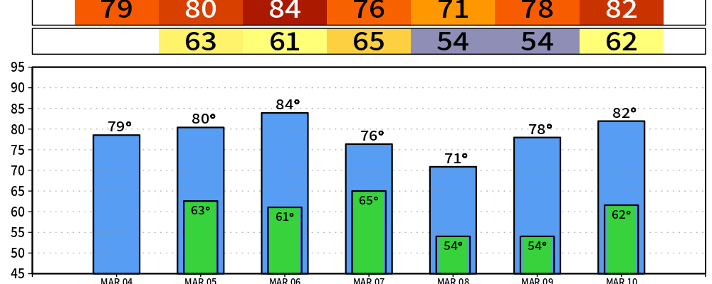
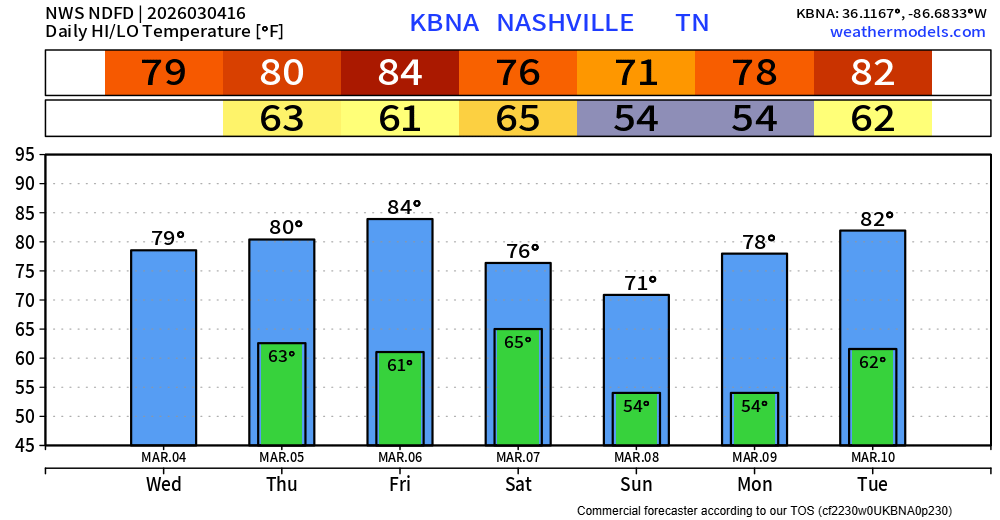
We’ll be on daily record temperature watch over the next several days, starting today.
Wednesday –> Forecast = 80° | Record = 84° (1976)
Thursday –> Forecast = 80° | Record = 80° (1910)
Friday –> Forecast = 84° | Record = 83° (1910)
Saturday –> Forecast = 76°*| Record = 80° (2000)
Tuesday (10th) –> Forecast = 82° | Record = 80° (2009)
Regardless of if we tie/break any daily record highs – it will be very warm. 20-25° above average for this time of year. The asterisk on Saturday refers to the possibility of us getting warmer than that, which will be dependent on what time rain/storms move in. More on this later.
The rest of this work week, most of us should stay dry. It’s possible a shower sneaks into the area sometime Thursday afternoon, but really do think most, if not all, of us stay dry and enjoy the warmth.
Rain/storms return to the forecast sometime Saturday during the day. Timing is a little uncertain right now, with models as early as mid-morning, others as late as the evening.
Models are in general agreement that there will be at least some CAPE (storm fuel) available, but shear looks quite lackluster. This leads me to believe we could perhaps see a strong storm or two, but the severe threat looks quite low at this point. This is something we’ll certainly be watching and will keep y’all updated with all the latest information as it comes in.
Low rain chances linger around Sunday and Monday as the cold front that brings us our rain/storm chances on Saturday sorta just hangs around. These would just be showers, no hazardous weather. If you have any weekend plans, having a rain jacket handy will be a good play.
Following that, our next legit chance of showers/storms appears to be next Wednesday. This is kinda out there in terms of model range, so there is quite a bit of spread regarding things. However, this will be the next time we keep an eye on things for the potential for strong storms, as the overall pattern set-up may be favorable – but again, lots of uncertainty. We’ll keep an eye on it!
Categories: Featured Blog