
- Winter Storm Warning will be in effect Friday night thru Sunday evening
- Increasing concern for damaging ice totals, 0.5 – 0.75″ possible, which could lead to power outages and tree damage
- Travel will become treacherous beginning Saturday morning, with prolonged impacts thru early next week
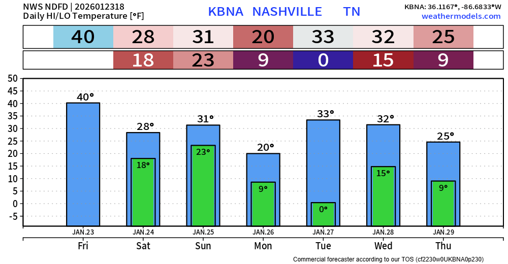
- Below freezing temperatures will last for days, wind chill values Monday and Tuesday morning near -5°
Our confidence remains high in an impactful winter storm this weekend that will bring prolonged impacts with a combination of snow, sleet and freezing rain. Details are becoming more clear, although there is still some uncertainty in the forecast. We’ll talk most likely scenario, then some caveats in the forecast that could change things. Preparation will be important for this event – hope for the best, plan for the worst. Stay connected for the latest updates!
Timing (Subject to Change) –
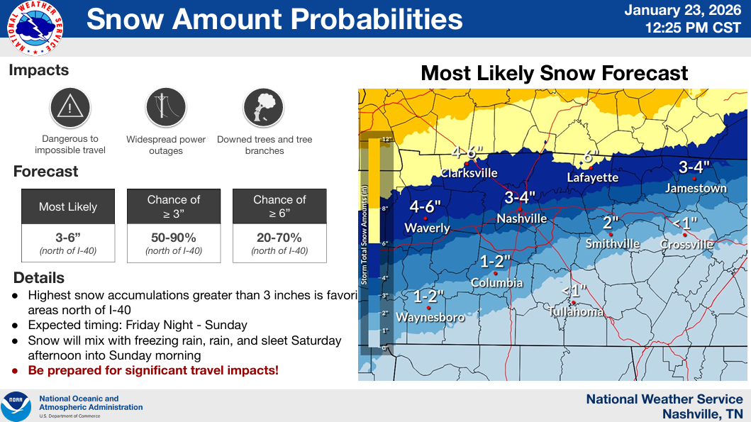
Saturday Morning –> We start out with all snow (around 6-8a), and likely when we see the bulk of it. Snow (heavy at times) will quickly start to accumulate, with travel conditions deteriorating quickly
Saturday Afternoon/Evening –> Likely begin a transition to a mix of sleet and freezing, probably mostly sleet early on, as the warm nose of air aloft moves in. Regardless of sleet or freezing rain, it will continue to accumulate
Saturday Night/Early Sunday Morning –> Probably all freezing rain at this point, ice accumulation will occur quickly
Sunday Morning –> This is when the most uncertainty exists – models predict surface temperatures will come close to, if not make it above 32°. We’ll either be dealing with freezing rain or a very, very cold rain at this point
Sunday Midday/Afternoon –> Thinking we transition back to freezing rain, maybe sleet/snow to finish things off as precip tapers off by around dinner
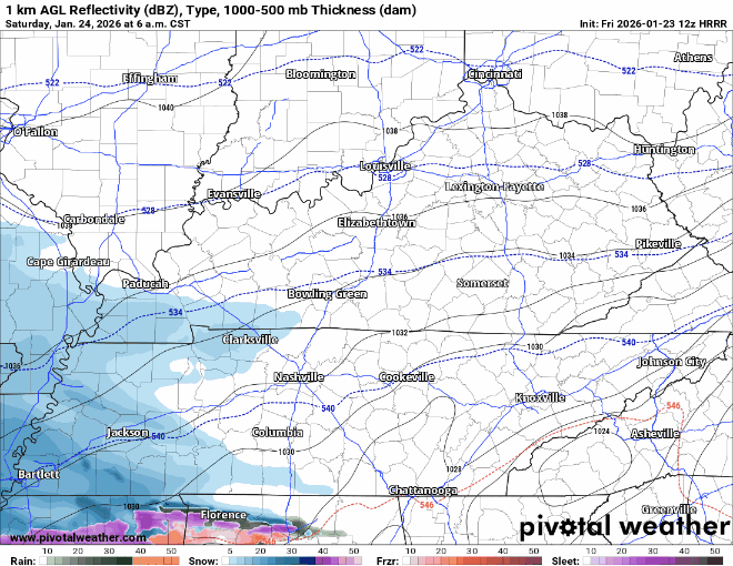
The HRRR model demonstrates this visually, but only thru 6a Sunday. We’ll see more of it later today. Not meant to be taken literally, but to be used as a general guide. Timestamp in the top left corner.
The current, most likely scenario calls for 0.5″ – 0.75″ of ice and 2 – 4″ of snow.
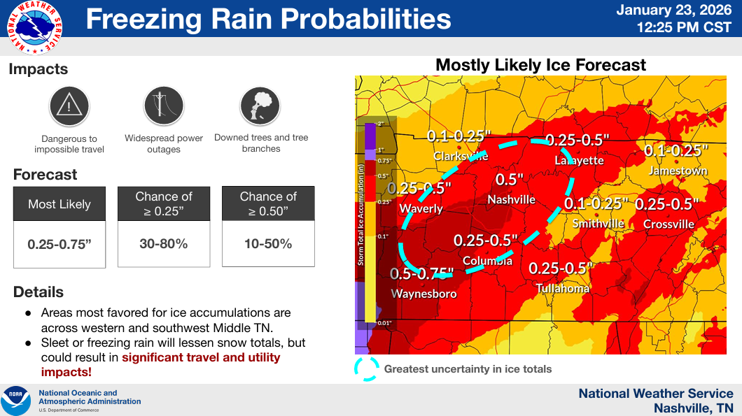
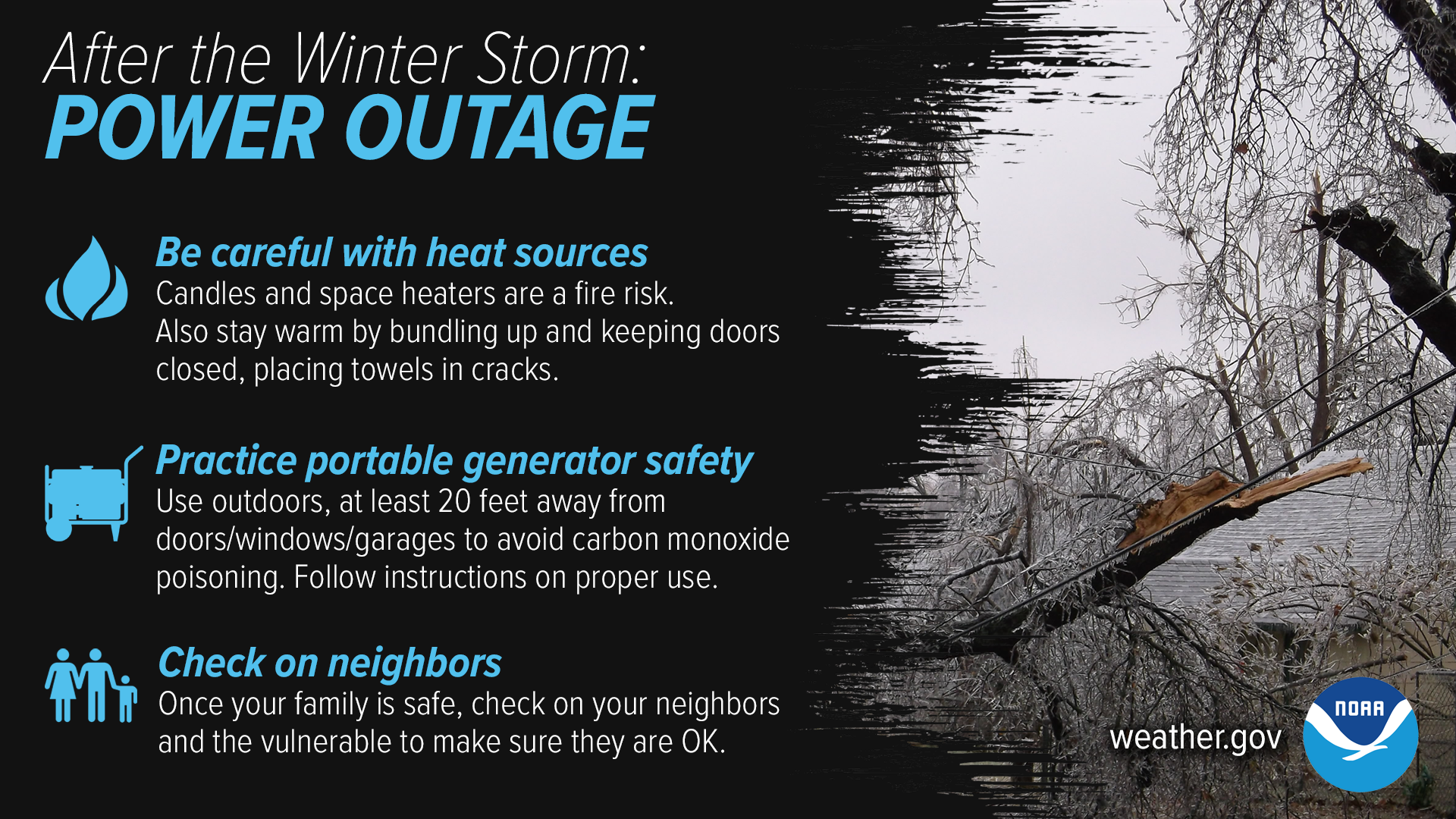
That amount of ice can quickly add up and become problematic, weighing down power lines and trees and causing damage and power outages.
The caveats to the forecast will mostly have to do with what our surface temperature do Sunday morning. If they stay below freezing the entire time (worst case), freezing rain would likely become even more of an issue. If they can get above freezing and stay there for a longer amount of time (best case), issues would be lessened – but not eliminated. The warm nose of air could also not be as strong as currently expected, leading to more sleet than freezing rain. This is something that will be decided by only 1-2° and will not be able to fully be realized until the event is underway. Stay connected!
Impacts/Action:
With power outages being a possibility, now is the time to prepare. Have ways to keep warm if you do lose power, especially with the brutal cold temperatures to follow. Have a generator? Make sure to run it today and ensure everyone works properly and use it at least 20 feet away from any indoor openings.
Travel will be difficult this weekend. Crews do a great job of trying to keep the main roads in as good of a shape as they can, but there is no guarantee – there is only so much your 4WD can do in ice. Back roads will especially be in rough shape for a while. Prepare to stay off the roads this weekend, have any errands done by tonight. The TDOT Smartway site will be a good resource to check road conditions.
Prolonged Brutal Cold:
We’ll drop below freezing tonight and won’t get much above it for at least the next 5 or so days. This will slow the melting process down, prolonging impacts. The sun should peek out some early next week, which will help some melting.
Temperatures will bottom out Monday and Tuesday morning. Low temperatures in the single digits – with wind chills below 0. Hypothermia can set in quickly with these conditions.
This is all the latest information as of 12:30p on Friday. Things could very well change, be sure to stay connected to all of our socials for the latest information. None of this is meant to scare you, just prepare you. Again, plan for the worst, hope for the best.
Best case scenario, surface temperatures go above freezing for longer than expected on Sunday and lessen (but not eliminate) our impacts). We’ll be here with you every step of the way.
Categories: Featured Blog