
At least twice on the briefing from the brilliant minds at NWS Nashville, I heard something along the lines of “this is a very difficult forecast.” I think that should speak for itself – prepare yourself to embrace uncertainty. You will not come away from this blog knowing exactly what is going to happen, but you will be more prepared.
What We Know:
- Confidence remains high that our area will see an impactful winter storm this weekend
- Travel will likely be negatively impacted this weekend
What We Don’t Know:
- Precipitation type (do we see all snow, sleet, freezing rain, a little bit of everything?)
- Totals (whether it’s snow or ice, it’s too early to guess exact amounts)
- Exact Timing (we have a general timeframe, but no specifics)
- How your flight/travel will be impacted
There’s been some shift/trends in the model guidance since yesterday’s blog. This is a great reminder that information can and will change, and it’s important to stay connected. We’ll be posting on all of our socials as needed. Uncertainty remains.
Timing:
Still have to be broad with this, but the latest model guidance shows any precipitation holding off until Saturday morning. This will last through at least the middle of the day on Sunday, possibly longer. To play it safe, I’d have your errands all done by dinnertime on Friday. This is very subject to change.
Precipitation Type:
This is by far what has changed the most over the last 24 hours. Yesterday, models overwhelmingly showed all snow for us. Now, most models think we very well could see a mixed bag of precipitation – including snow, sleet, freezing rain, rain. Any sleet or freezing rain would cut down our snowfall totals but could introduce a whole new set of problems with ice accretion. Where exactly we see the transition of snow to mixed precipitation will be very tricky to nail down.
“We’ll continue to monitor the trends, but I feel fairly confident there will end up being a tight gradient of heavy snow to sleet to freezing rain. Where that ultimately settles, we’ll see.” – NWS Nashville
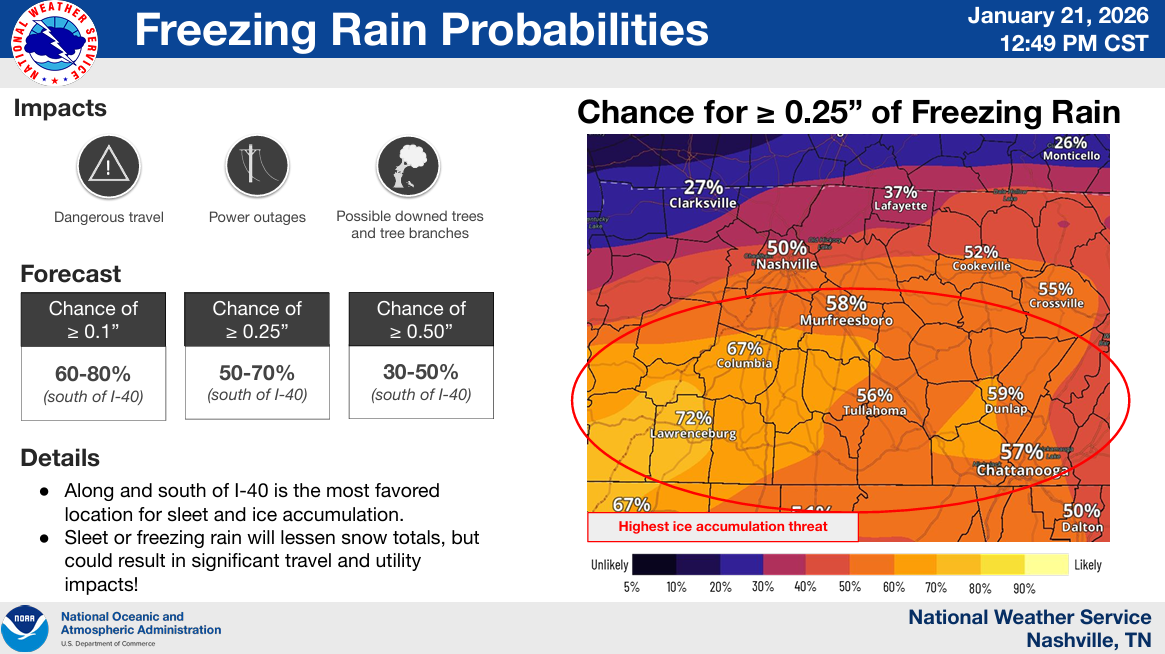
Totals:
This is where a lot of uncertainty lies. Where that gradient between snow –> sleet –> freezing rain sets up will be very important.
The graphic below shows probability of at least 0.25″ of freezing rain, which has changed quite a bit from yesterday. Our odds have gone from ~20% –> ~50%. This is certainly something we’ll be watching, this amount of ice can easily cause more problems than a couple inches of snow.

The probabilities for snow have come down, especially S of I-40, but they are far away from 0. Latest odds give Nashville roughly a 50% chance of seeing at least 6″, lower odds the more S you get.
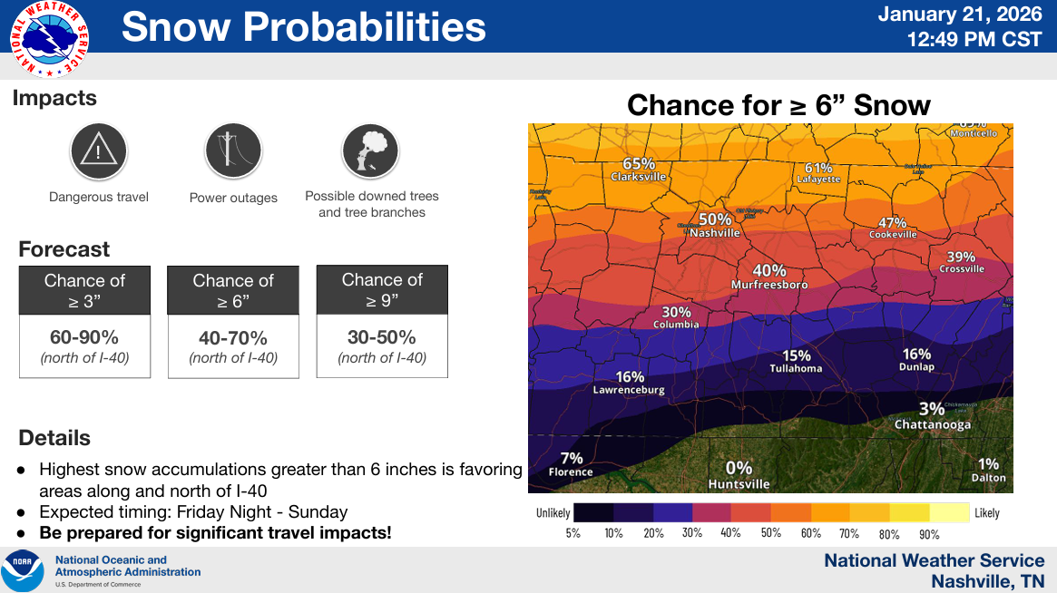
Bottom line is, areas N of I-40 have a higher chance for snow, areas S of I-40 have a higher chance for freezing rain – for now.
Impacts:
Regardless of if we see snow, sleet, or freezing rain – travel is likely to be impacted this weekend. With cold temperatures in place, whatever starts to fall, it won’t take it long to begin accumulating.
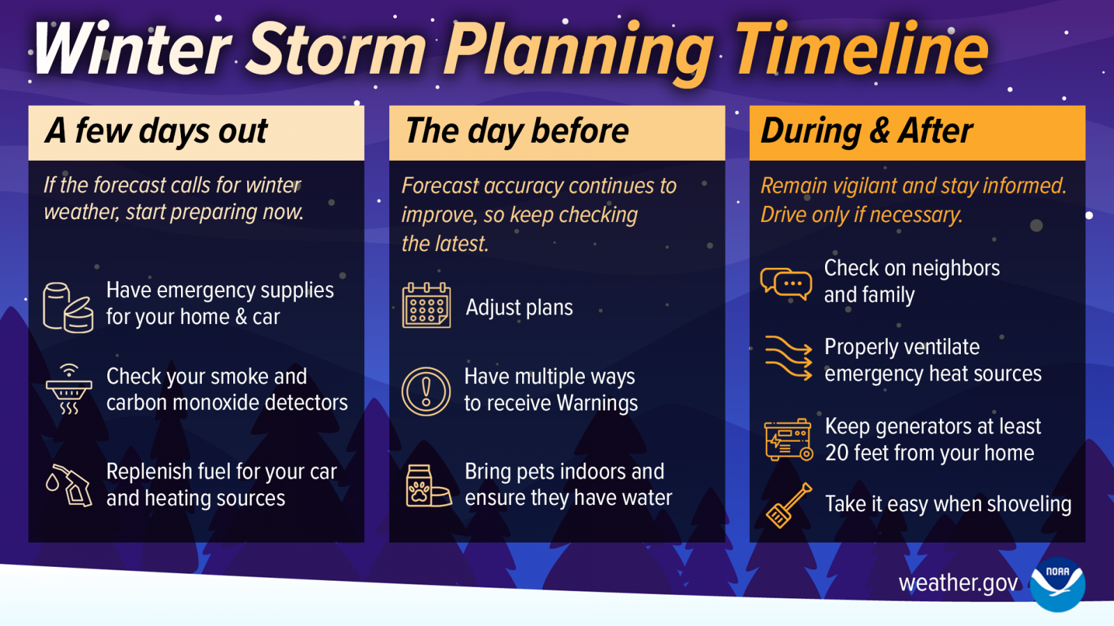
I would certainly reconsider any traveling this weekend, as travel may become very difficult. By the looks of it, most everyone has gotten the memo to go to the grocery store early this week. Please be kind and patient to one another in there.
We are still in the “A few days out” frame. Not a bad idea at all to think about checking off those boxes.
Prolonged Event/Dangerous Cold:
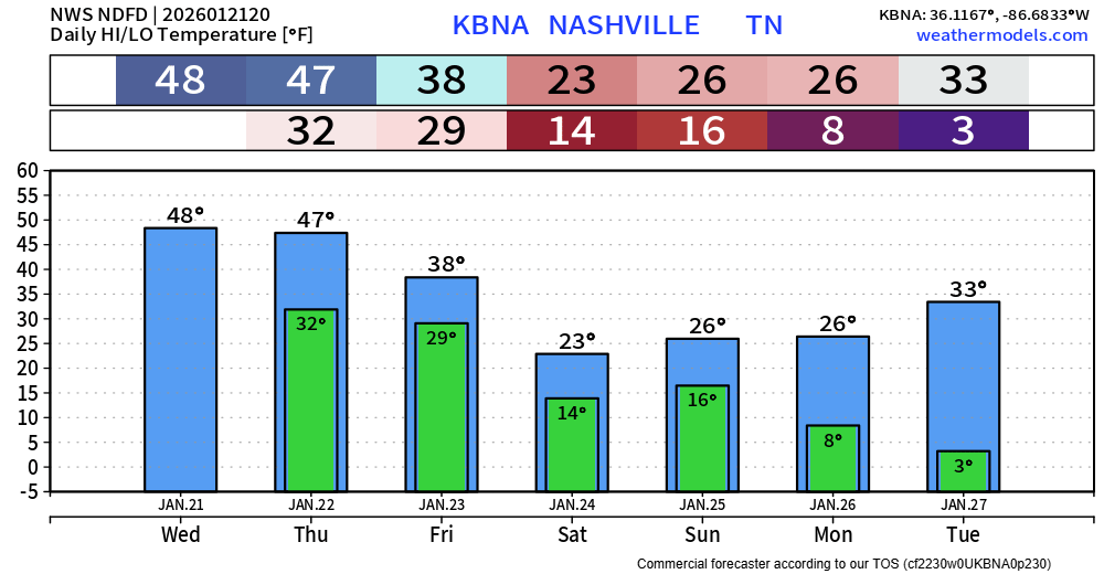
Whatever falls will likely stick around for a good while. Temperatures are not expected to make it above freezing until Tuesday or Wednesday, and only briefly at that. Although the sun can still help out.
Several mornings next week, particularly Monday and Tuesday morning, will be spent waking up with temps in the single digits.
We’ll continue to watch model trends and look at all sorts of data. Information will change, stay connected!
In other news, rain will continue thru this evening, tapering off tonight. All rain, no frozen stuff.
Categories: Featured Blog
Thank you!