
What We Know:
- Confidence is increasing that we see impactful winter weather this weekend
- Models have been quite consistent on thinking that we could see impressive snow totals
- Travel will likely be impacted across the region this weekend
What We Don’t Know:
- How much it will snow in your backyard
- What time it begins in your backyard
- If school will get canceled
This is all the latest information – and can (and will) change. Predicting winter weather around here is hard, especially still ~100 hours out. There is still a good amount of uncertainty with this. Stay connected for the latest info!
Timing:
Early indications (very much subject to change) show that precipitation starts sometime late Friday night into early Saturday, tapering off sometime Sunday. That’s a pretty broad timeframe, but that’s just about as specific as it can be right now.
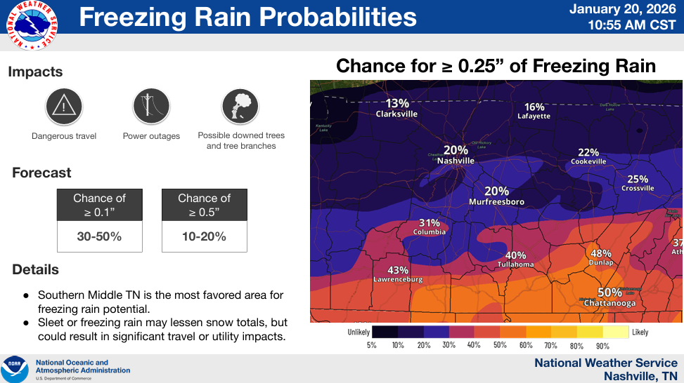
Precipitation Type:
Most models are pretty set on thinking this will be all snow for us. There are a couple runs of some different models that think we could see some freezing rain mixing in towards the end of this event. At this time, it seems like the highest probability for freezing rain stays to our south (see graphic below). Most of the time, freezing rain is more impactful than snow, so no thank you. This is something we will absolutely be watching.
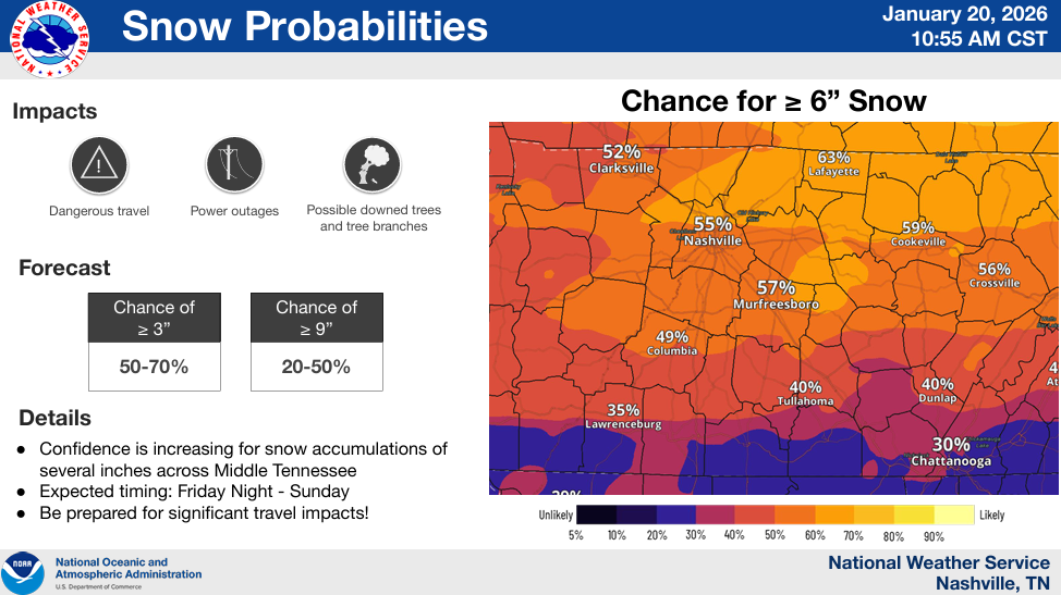
Snowfall Totals:
I’ve seen it all the past few days, from 0″ to 30″. My guess is somewhere in between.
But seriously, it’s too early to be throwing out forecast range totals. We aren’t in range of the high-res models yet – which I’d like to see their take on this.
The GFS has been all over the place, which is not totally surprising. The Euro model has stayed consistent on its’ thinking, continuing to show impressive snowfall totals.
Even the usually more conservative ensembles (GFS, Euro) show some solid totals for us. The National Blend of Models (NBM) continues to increase snowfall totals for us as well. All of this data has driven confidence up.
At this range, I’m going to lean on statistical probabilities from the NBM. I think they give the best assessment.
Chance of “x” Amount:
3″+: ~75%
6″+: ~55%
8″+: ~50%
These numbers are all off of the 13z run of the NBM – and they will change, higher or lower.
Impacts:
Regardless of the wintry precipitation we receive – snow, freezing rain, or sleet – travel is likely to be impacted across the area this weekend.
Currently, we (and lots of others) have at least a 90% chance of at least “minor” winter weather impacts this weekend.
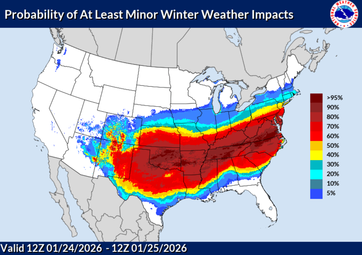
If you have any plans this weekend, I would go ahead and start rethinking them about now and adjust your plans accordingly.
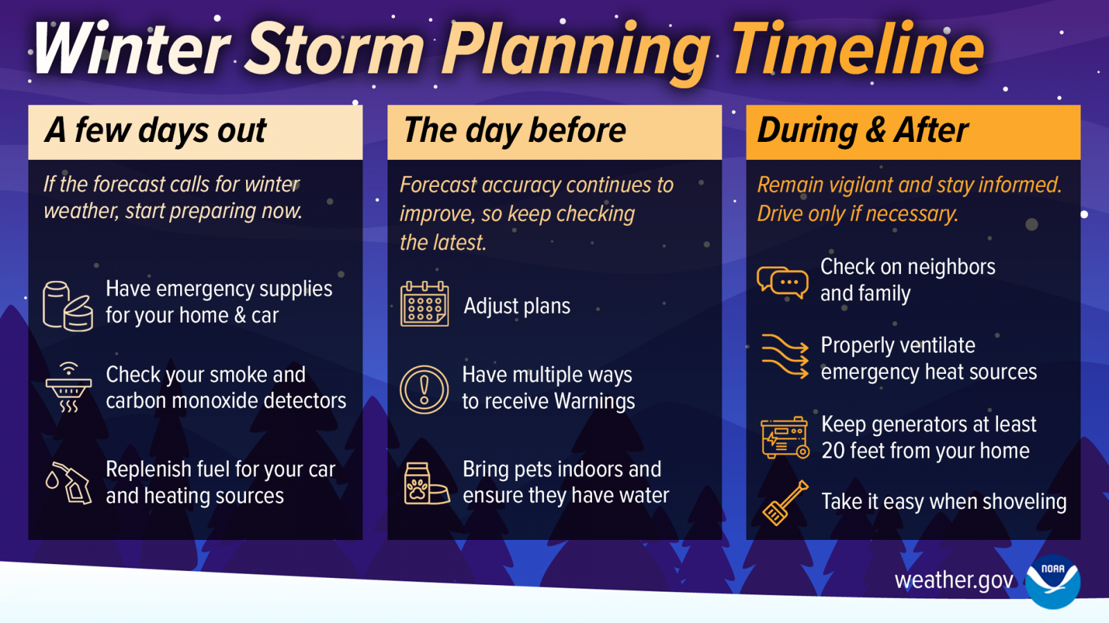
The talk of all this winter weather will send people into a frenzy – storming the grocery store for bread and milk. I personally, would grab different items, but that’s just me. Regardless, it wouldn’t be a bad idea to grab some stuff earlier this week if you normally do your grocery shopping on the weekend. We are currently in the “A few days out” timeframe in the graphic below.
Prolonged Impacts:
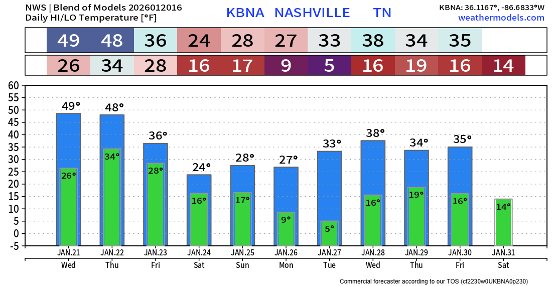
Any impacts will likely be prolonged, as temperatures could stay below freezing until Wednesday. This includes a couple mornings with low temperatures possibly in the single digits.
That’s a lot of info. We’ll continue to keep y’all posted with all the latest info on all of our socials and daily blogs. Continue to stay connected for the latest info, as all of the info in this blog could very well change.
In other news, we’ll likely see some rain Wednesday afternoon/evening. Maybe a few flakes mix in early Thursday morning, but no accumulation/impacts – this will likely be all liquid.
Categories: Featured Blog
Now the Euro is backing off their totals and everything else seems to be going up. May end up being a wild one, may end up being a bust! Welcome to Tennessee!!!