
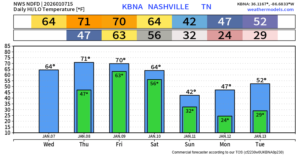
Before we jump into the heavy rainfall and maybe severe weather talk, I would like to highlight the well above average temperatures we’ll see today thru Friday. Our record daily high for Thursday and Friday is 71°, so we’ll likely either tie or come very close to breaking it both days. Our low of 63° on Friday is expected to shatter the daily record warmest low temp of 59° set in 1880.
I’ll lead with what I think will be the “main” part of Friday – I’m not sure if that’s the best word to use but I’ll go with it.
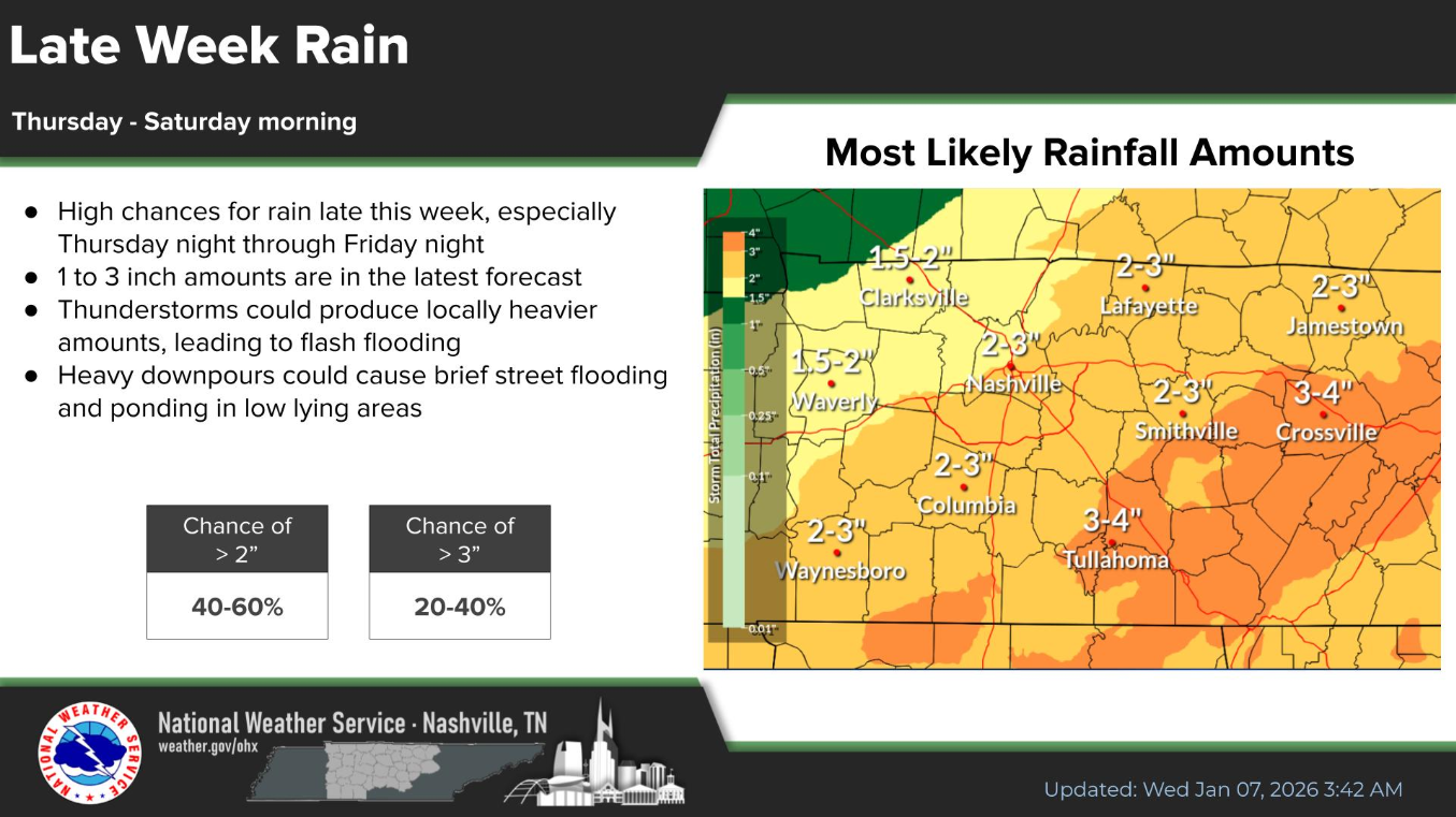
2-3″ of rain is now expected to fall Friday morning thru Saturday morning.
Those amounts in itself spread out over 24 hours is not that big of a deal, we can handle that. What we’ll be watching is that possibility of those amounts coming down over a few hours, which could lead to some isolated flash flooding. We’re still out of range for the high-res models (won’t be the last time I say that), so it’ll be interesting to see what those come in with. For now, the heaviest rainfall may stay off just to our east and south – but this bears watching.
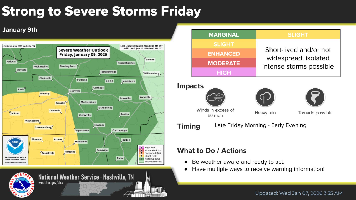
Our severe weather threat remains conditional, with lots of questions that have yet to be answered.
The SPC continues to outlook our areas with severe probabilities, with mostly WillCo. outlooked with a 15% chance of severe weather, Davidson Co. with a 5% chance of severe weather, both within 25 miles. Try not to pay too much attention to exactly where the lines are drawn – this will likely change.
A general timeframe right now appears to be Friday afternoon thru Friday night, but this could change.
The glaring question we’ve talked about over the past several days remains – will the storms have any CAPE (storm fuel) to work with? We’re still out of range of any high-res models (told you), so we have yet to see their opinions, but the global models (GFS, Euro), think we get very little to none.
Models can have a bias to underestimate the amount of CAPE during winter, so this will be something to keep in mind. It’s also worth noting that we could very well see some (non-severe) storms Friday morning thru mid-day, which could prevent us from clearing out and seeing any CAPE.
Bottom line, there are more questions than answers right now. High-res models will start to come into range tonight, which will help. This remains to be a low-end severe threat, with more confidence in our heavy rain threat. As always, we’ll keep y’all posted with the latest info on all of our socials and in future blogs.
Rain should clear out by Saturday morning and we’ll begin our journey to more seasonal temperatures.
For those wondering if we’ll see any snow – long range models don’t give us any strong signals over the next two weeks.

Categories: Featured Blog