
Our dense fog should begin to mix out here over the next several hours. For now, leave plenty of room between you and other cars if driving and use your headlights.
Today we get temps in the low 70s and plenty of sun. If you don’t already have outdoor plans, maybe you can make some.
A cold front will pass thru early Sunday morning – and we’ll see some dramatic temperature changes.
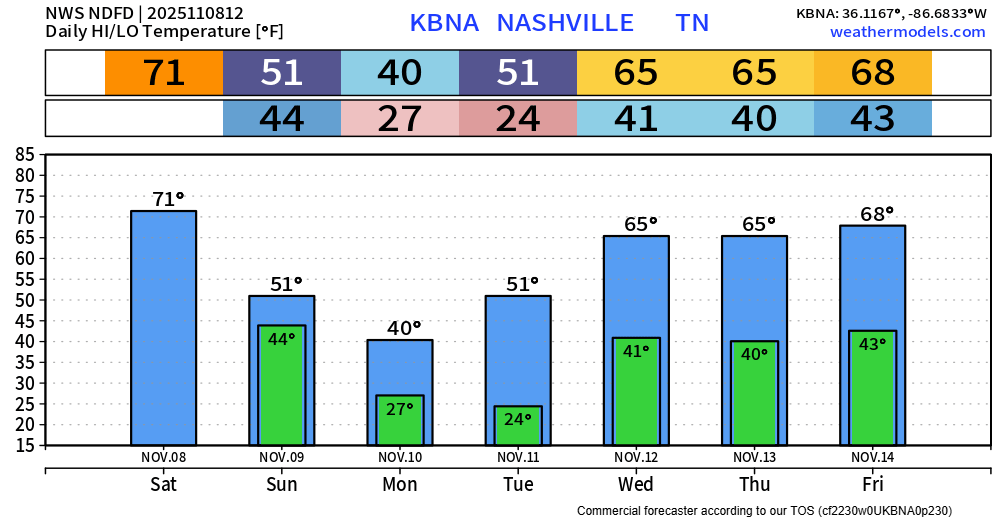
High temperatures Sunday will struggle to make it out of the 40s, with our high temp likely occurring around 1 or 2am.
Monday morning we’ll wake up to temperatures as cold as they’ve seen in quite some time. Air temps in the mid 20s combined with a brisk NW wind = wind chill values near 15°. Multiple layers will be needed for the bus stop.
We may have just enough moisture left in the air on Monday to squeeze out some flurries, but no accumulation or impacts are expected. These would splat:melt on impact with the ground. Cool to see, no impacts. Regardless of the flurries, high temps may not make it out of the 30s.
Tuesday morning will be similar to Monday’s – air temps in the low to mid 20s, with wind chill values near 15°.
Thankfully, temperatures will rebound nicely by Wednesday with highs returning to the mid 60s. No additional rain chances thru at least Friday.
Categories: Featured Blog