
Thinking on today’s low-end severe potential this afternoon and evening largely remains the same.
In short: damaging straight-line will be the main threat with any strong thunderstorms this afternoon and evening, but a tornado or hail cannot be ruled out. Stay weather aware, especially those with outdoor plans, and have a way to receive warnings in case one is issued for you. Lots more deets below.
Confidence continues to increase regarding our low-end severe weather threat, expected impacts and risks remain basically the same.
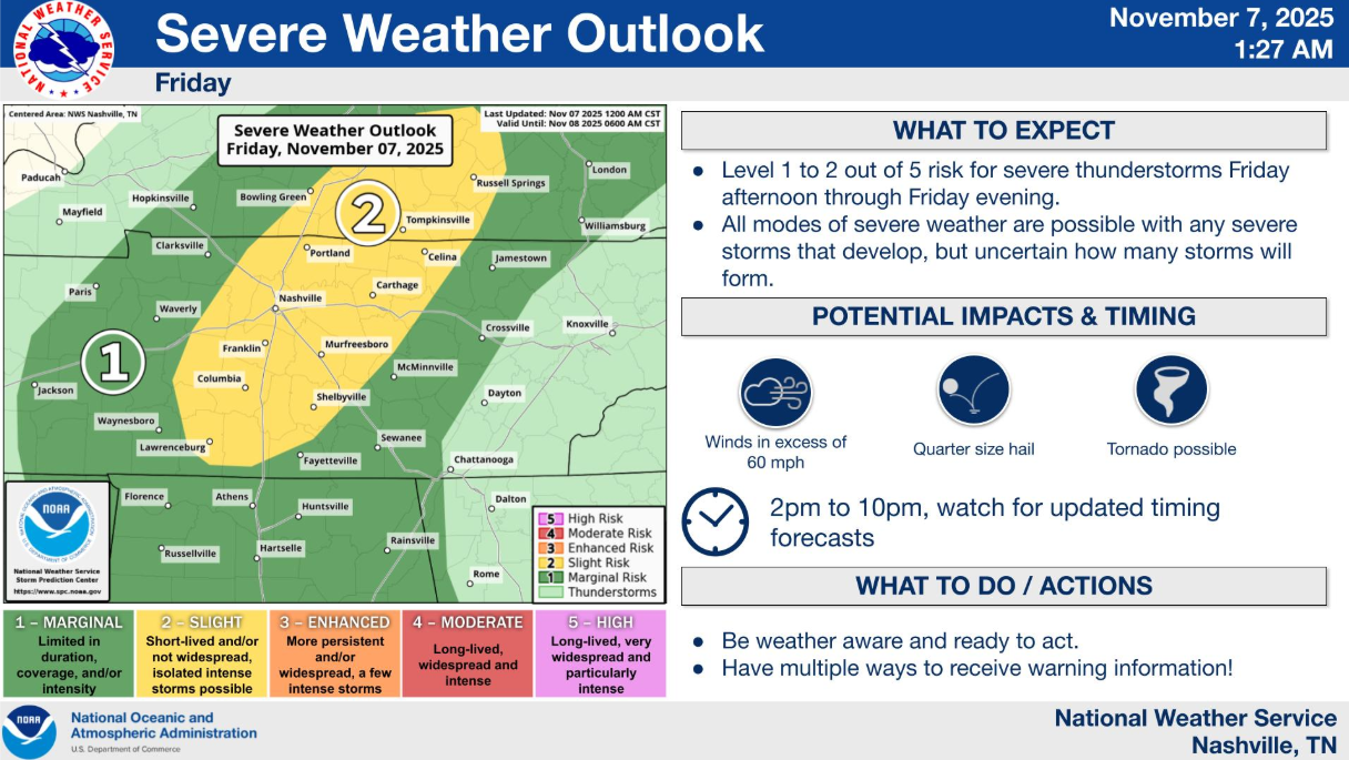
Probabilities: The SPC has our two counties outlooked with a: 15% chance of damaging straight-line winds (58mph+), a 5% chance of severe hail (1″+), and a 5% chance of a tornado – all within 25 miles.
Again, main thing we’ll be focusing on is the possibility of damaging straight-line winds, but we can’t rule out some hail or a tornado.
Timing:
Timing has got pushed back just a tad.
Pondering over the models, they generally agree on a rough timeframe of 3p-8p. It won’t storm this entire time, but that’s about as specific of an ETA window I can give right now. *Subject to change*
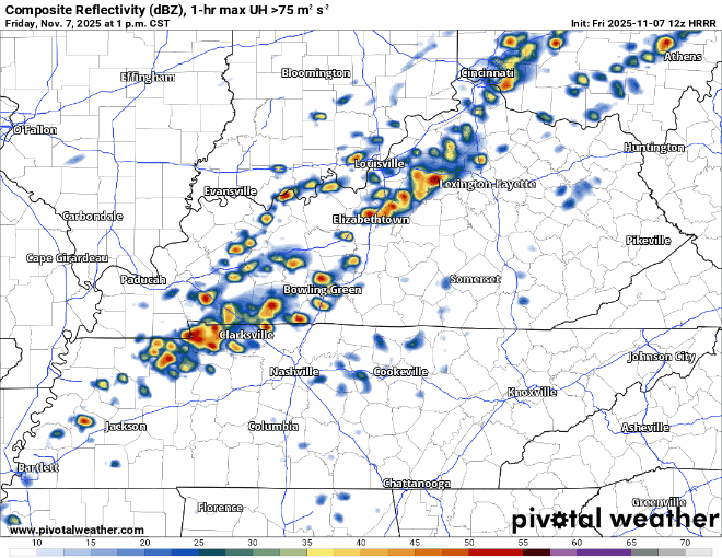
The HRRR model (to be used as guidance, not gospel), gives a guesstimate on what the radar could look like.
The “Why”:
Nerdy quote from the incredibly smart minds at NWS Nashville below – for fellow nerds.
“Forecast soundings associated with the pre-frontal environment are not all that impressive. Instability parameters have increased, but the soundings reflect a proverbial “tall, thin CAPE,” which would certainly enable storm development, but not the type of updrafts we would need for widespread severe storms…we cannot completely rule out all modes of severe weather, but the risk of large hail and tornadoes is certainly minuscule.”
Less nerdy translation: we’ll have the shear (winds changing with speed and direction with height) available, we’ll have enough moisture (dewpoints in the low 60s), it now appears there will be enough lift to get the storms going, and there will be some storm fuel (CAPE) – but certainly not a lot. The limitation on storm fuel will be our friend and should keep the severe threat limited.
All these parameters are calculated by forecast models. Models are far from perfect, and we’ll be looking at observations today to confirm whether or not these parameters show up.
What To Do:
Stay weather aware today and have a way to receive warnings. While it’s not super likely you’ll get any sort of warning, with us entering our second severe weather season, now is as good of a time as ever to be prepared.
NOAA Weather Radio (best!), Wireless Emergency Alerts on your mobile device, wake-me-up app, are all ways to receive warnings. Do *not* rely on sirens as a way to get warnings.
Those in charge of outdoor plans (including the HS football games) should start thinking about safety protocols. With the ETAs being pushed back a bit, the start of games could be in jeopardy. Regardless of a storm is severe or not, it will likely contain lightning. You should be in an enclosed building while these storms pass.
As a reminder, this remains a low-end threat. There’s a 95% chance you don’t see a tornado within 25 miles of you. Those are some pretty solid odds, but it isn’t a guarantee. Don’t let this threat sneak up on you, know what to do if a warning is issued for you. Also, for those of you new to the area – first off, welcome. Secondly, be able to pinpoint your home/work on a map. You won’t know if a warning is issued for you if you don’t know where you are! We have a great article here with more on preparing/what to do: What To Do | Nashville Severe Weather
Severe weather can get some heartrates up, and understandably so. We have a wonderful article here on taking care of storm anxiety: Taking Care of Storm Anxiety | Nashville Severe Weather. Take care of yourself.
Lastly, this threat will not linger into the overnight hours. We’ll be able to give the all clear before (most) of you go to bed. We’ll be sending out updates all day on all of our socials (X/IG/Threads/BlueSky) and will go live on YouTube if a warning is issued for any portion of our two counties.
Models think we stay dry all of Saturday now. All in all, it will be a really nice day with temps getting into the low 70s. That will probably be the last time we see 70° for a while, so I’d recommend making outdoor plans if you don’t have some already.
A cold front will swing thru the area early Sunday which could bring some light showers during the day, but the main talk will be the cold air it brings in.
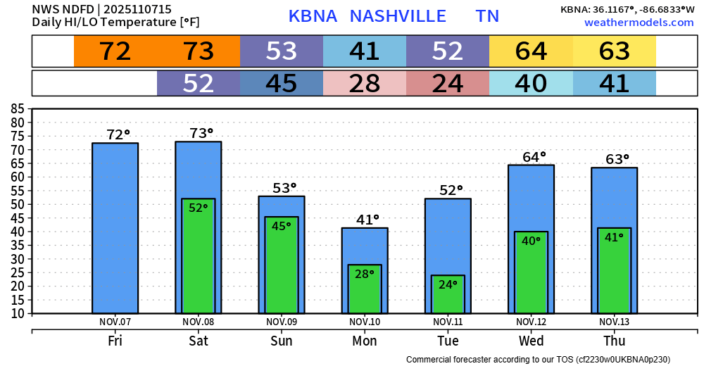
Monday and Tuesday morning we’ll see the coldest temperatures so far this season – with lows getting down in the low to mid 20s. This will be the first time we officially get to freezing this Fall. We’ll struggle to get out of the 30s on Monday.
The Euro remains steady with the thinking that we could see a few no worry flurries during the day Monday. No accumulation or impacts are expected. If we are lucky enough to see flurries, they would melt on impact with the ground. If you keep your hopes down, you can’t be disappointed.
Temps will rebound nicely by the middle of next week, getting back up towards average for this time of year.
Categories: Featured Blog