
Another Air Quality Alert in effect for today.
“The general public is not likely to be affected. Active children and adults, and people with a respiratory disease such as Asthma, should limit prolonged outdoor exertion.”
Yesterday models were fairly confident that we would see a dry Friday and weekend.
Today, models think only some of us see a dry Friday and weekend.

Chances are still fairly low at ~20%, but each afternoon and evening thru Sunday some of us could see an isolated shower or storm. A storm or two may contain lightning and gusty winds, but no severe concerns. Models currently think those W of 65 have the “best” chances – but chances all around are low.
Those with outdoor plans during this time should keep an eye on the radar – but proceed. Most of the rain/storms should be gone by kickoff tonight for those attending local HS games.
Higher, more consistent rain chances arrive on Monday and stick around for most of next week. Timing and such is still fuzzy, but we’ll keep you updated.
We could finally get some decent rainfall from this, some models think we get ~1.5 – 2″ of rain between now and next Friday. We sure could use it, but that number could also change.
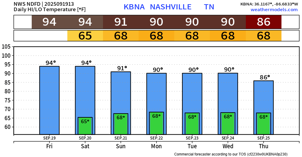
High temps in the mid 90s (10°+ above average) finally relax after today and Saturday. Still, highs near 90° thru the middle of next week.
Dewpoints also creep up early next week into the mid/upper 60s. That’s the air you wear as soon as you step outside.
Long range guidance continues to think we see temps leaning above average thru the next 10-14 days. Our latest 90° temp is October 19th, 2016 – if you were curious.
Our average first freeze is October 29th – for fans of that.

Categories: Featured Blog