
Another scorcher today, BNA peaked at 98°.

Although it remains unlikely, a few folks could see a shower or storm this evening – but think majority of us stay dry.
We have just one more Heat Advisory to get thru this week, valid Thursday until 8p.
Heat index values will climb up around 105° yet again.
Continue to take it easy outdoors. Take frequent breaks, stay hydrated, and watch out for signs of heat illness.
Not-so-fun fact, Thursday will be our 30th consecutive day at 90°+. Fifth longest streak on record.
Thankfully, Friday will disrupt that streak as we finally get a break from the 90s.
It’ll still be hot – but high temps will “only” be in the mid to upper 80s thru at least early next week.
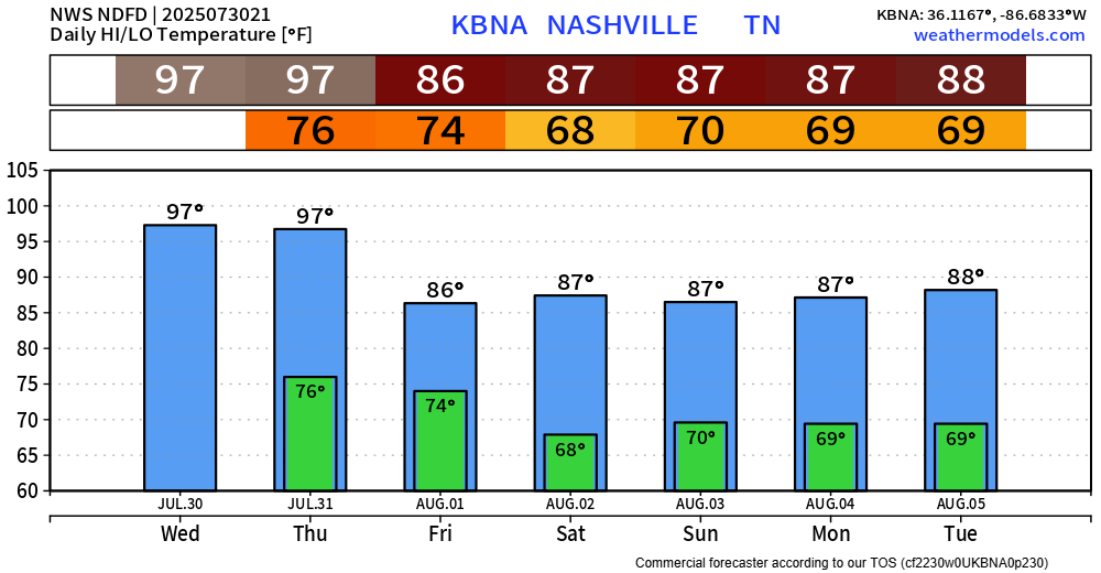
Long range models think our 90s return late next week, so try and enjoy the 80s while we can.
Starting Thursday, our rain chances will increase a bit towards the 30-50% range thru at least early next week.
HRRR model likes our chances for a shower or storm on Thurs. Not totally sold on that idea just yet, even high-res models have a hard time handling our summertime atmosphere.
With that being said, rain/storm chances on Thursday, and every day thru early next week, will peak during the afternoon and evening. Impossible to nail down any specific ETAs, those with outdoor plans should remain weather aware and stay connected.
We are not outlooked with any severe chances by the SPC, but any storm could contain heavy rain, frequent lightning and gusty winds. Isolated flash flooding will continue to be a threat with any slow-moving or training thunderstorms.
Categories: Featured Blog