
We continue to have an Extreme Heat Warning until 8p Wednesday.
Heat index values up to 113° will be possible during the afternoon and evening.
Heat illness can occur quickly with conditions as hot as this. Please, take it easy if you have to be outdoors for a long stretch. Take frequent breaks, stay hydrated, and watch out for others.
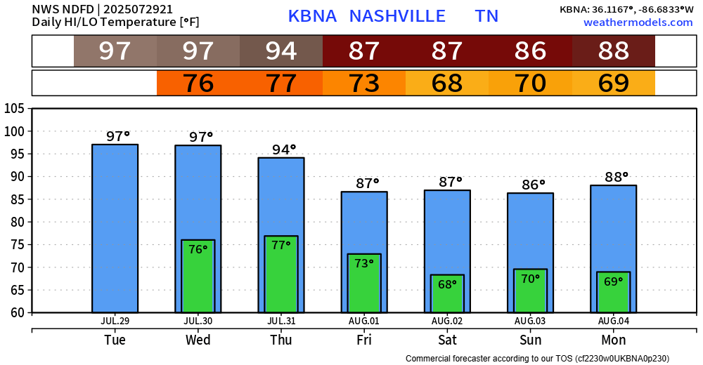
Thursday temps will come down a few degrees, but it will still be hot. Thursday will likely mark the 30th consecutive day we make it to 90°. Thankfully, it looks like that streak will end as we close out July.
While temperatures remain hot, the beginning of August will provide some relief as high temps will be in the mid to upper 80s – a nice change from the upper 90s. Dewpoints will also relax into the mid 60s, you’ll certainly be able to feel the difference.
Any showers or storm will remain quite isolated on Wednesday. Most of us will likely stay dry.
Chances bump up towards 40-50% for Thursday and Friday, still most likely in the afternoon and evening.
Any storm you may see could contain heavy rain, lightning and gusty winds. It’s Wattery style, so still impossible to know exactly when and where. Those with outdoor plans should remain weather aware and keep an eye on the radar -along with our socials!
Low to medium Wattery chances stick with us thru the weekend – but still no severe weather concerns.
Categories: Featured Blog