
It’s still hot today, but just not hot enough to get us into Heat Advisory criteria.
Sunday thru Wednesday – we’ll have no problem getting there.
Heat index values in the 105-110° range will be likely.
We’ll especially be watching Monday thru Wednesday, as some places could see some heat index values up to 115°. NWS Nashville will be watching what the models do, if confidence is high enough in those 110°+ heat index values – we could see an Extreme Heat Warning.
Regardless, it will be hot. Actual air temperatures will make a run at 100° on Tuesday and Wednesday.
If you must be outdoors for long periods of time, please take it easy. Take frequent breaks, stay hydrated, and check in on your neighbors.
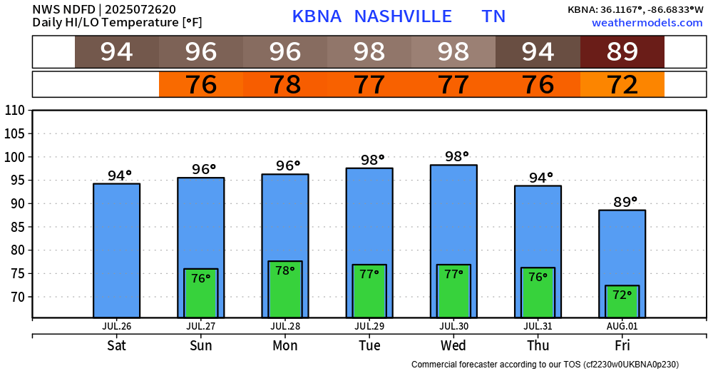
Today (Saturday) marks 25 consecutive days above 90°. It seems likely that we reach 30 consecutive days by the end of July. Thankfully, think that streak gets broken early August.
As for rain, chances stay around 20-30% thru Wednesday before they bump up a tad towards the end of next week.
No severe weather in sight, but any storm could contain heavy rain, lightning and gusty winds.
Any showers or storms will continue to be Wattery style, so impossible to know exactly when and where. Know that’s not ideal for any outdoor plans, but if you keep an eye on the radar (and of course our socials) then you’ll be good to go.
Categories: Featured Blog