
We continue our unsettled pattern thru Tuesday.
I know I sound like a broken record, but scattered showers and storms will be possible daily, mostly confined to the afternoon and evening. Some will see some heavy rain, while others see none.
Our atmosphere continues to be loaded with moisture and energy, so any thunderstorm may contain heavy rain, frequent lightning and gusty winds. Be cautious of any isolated flooding, and if thunder roars – go indoors. Still not expecting any organized severe weather.
Impossible to know exactly when and where these storms pop up. If you have outdoor plans, stay weather aware and keep an eye on the radar. We have one you can use on our website, or you can use your favorite one, no pressure. Radar | Nashville Severe Weather
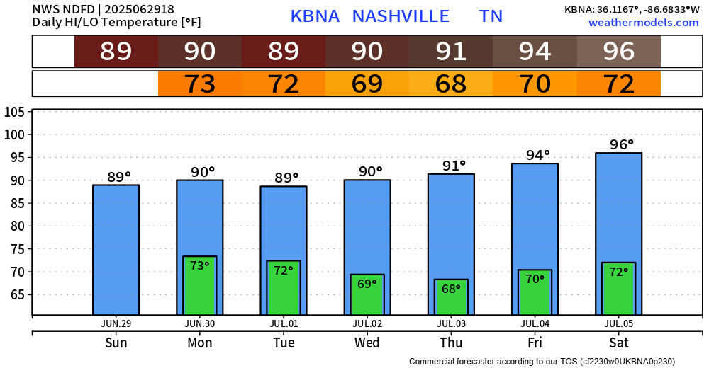
A front will pass thru on Tuesday, which will bring us our rain chances for then – but following the frontal passage, we might finally get a few dry days strung together. Humidity levels will also drop a tad, dewps will still be in the upper 60s though.
Rain chances will be very low for the second half of the week, Wednesday thru at least Saturday. Still lots of time between now and then, so things could change – but this is good news for your 4th plans.
Our tradeoff will be temperatures will creep back into the mid 90s as we progress thru the week.
Categories: Featured Blog