
Our 12z morning sounding from BNA today looks fairly similar to yesterday’s. No coincidence – much of the same can be expected. Our atmosphere will look fairly similar each day thru Tuesday.
We’ll be dealing with medium to high chances of a shower or storm, mostly confined to the afternoon/evening thru early next week. No organized severe weather is expected, but as we’ve seen, any thunderstorm could contain heavy rain, frequent lightning and gusty winds. If thunder roars – go indoors. Also, isolated flooding cannot be ruled out, as storms will tend to move very slow.
It’s Wattery style – so unfortunately impossible to know exactly when and where these storms may pop up. If you have outdoor plans, please stay weather aware and keep an eye on the radar. These storms can pop up quickly and start throwing lightning just as quickly. You can check the radar anytime on our website: Radar | Nashville Severe Weather
Chances will be highest Sunday thru Tuesday. Wednesday and onward any Wattery chances will be very low, with coverage much more isolated.
While we are finally not under a Heat Advisory – it will continue to be hot and humid.
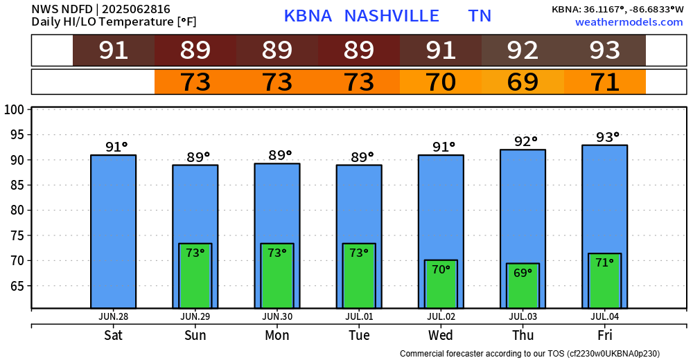
High temps will continue to be in the upper 80s/low 90s, with dew points in the low 70s – that’s still a gross combo.
Too soon to know for sure look at the 4th continues to be hot with some scattered showers and storms possible. Still way too early to know any specifics. We’ll be watching.
Categories: Featured Blog