
“Astronomical summer kicks off today at 942 PM CDT, and right on cue, here comes a heat wave” was the opening line to the midday area forecast discussion from our friends at NWS Nashville – which I thought was very fitting.
Sunset will be at 8:07p tonight – the latest it will get. It will slowly start getting earlier from here on out.
Today was hot – and it will only get hotter.
While this isn’t record-breaking heat (most daily record highs are in the 100-102° range), it will still be dangerous heat.
Highs and lows will be incredibly consistent Saturday thru at least Thursday. Really as consistent as I’ve seen in a while, at least for our area.
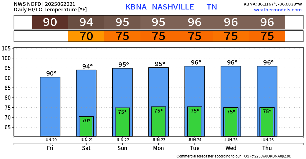
High temperatures in the mid 90s paired with dewpoints in the low to mid 70s will easily send heat index values to around 105° Saturday thru at least Thursday. Heat Advisories will probably be needed for several days.
Please take precautions if you plan on being outdoors. Yes, this is summer – but we haven’t seen temperatures like this since last summer.
Stay hydrated, take frequent breaks, and try to wear light-colored and loose-fitting clothes.
Never leave anyone (or pets) in a car – even if you are “just running inside quickly.”

Each day will carry a very low chance (~10%) of a quick afternoon/evening shower/storm to cool us down. Although unlikely, when thunder roars – go indoors. But the heat should give you a good enough excuse to go inside regardless.
“Extended models show the ridge starting to break down next weekend with temps backing off and shower/storm chances creeping upward.” – NWS Nashville
Categories: Featured Blog