
We’ve seen quite a bit of rain already today, with more moving thru as of the time of writing (3:30p). Activity should decrease as we head closer to sunset. You can check the radar anytime on our website here: Radar | Nashville Severe Weather – and we’ll be sending out updates on all our socials as needed.
The pattern of scattered showers and thunderstorms during the afternoon/evening will continue to be the theme for at least the next week…

Saturday will have the highest chances at about ~80%, similar to today, widespread showers and thunderstorms will be likely.
Every other day, Wattery winners will still be likely, but maybe fewer – with more isolated storm coverage.
Overall severe risk will be low, but as we saw today – these storms can pulse up and become briefly severe.
Impossible to know exactly when/where showers and storms will be each day. For those with outdoor plans (and those at The Farm), your best bet is to stay weather aware and keep an eye on the radar, and our socials. When thunder roars, go indoors. Heavy rain and lightning will be possible with any thunderstorm.
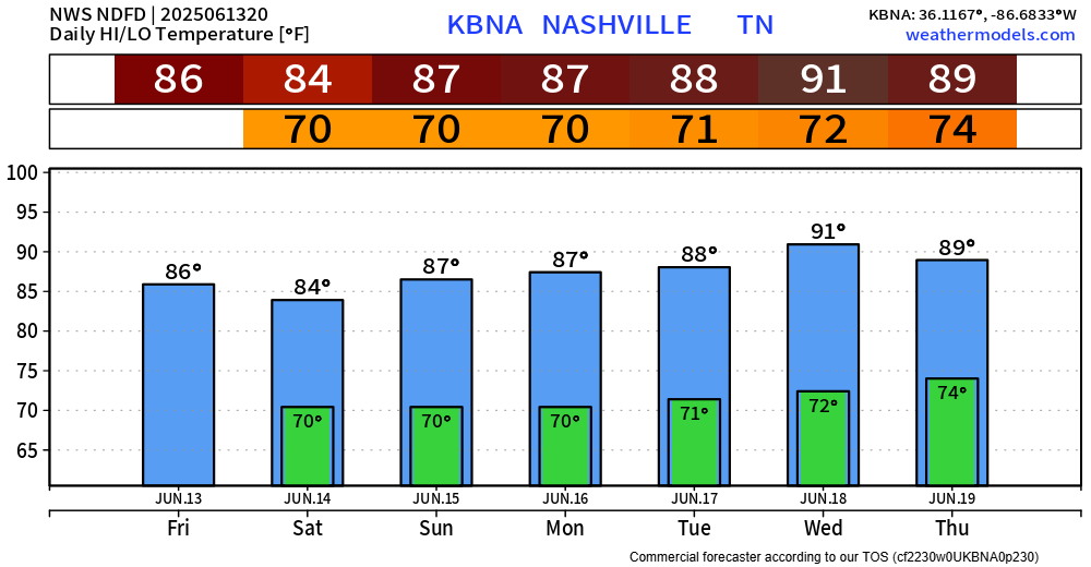
Along with our rain chances, high temperatures will be in the mid to upper 80s, with dewpoints in the low 70s. Which classifies on the ‘official’ chart as Oppressive.

High temps will gradually increase over the next week.
Categories: Featured Blog