
As of the time that I am writing this (7:45p), there are a few cells to our north that are slowly drifting south. With the loss of daytime heating, not too confident in those making it here. If they do, it would just be a quick shower, maybe a rumble of thunder. As always, you can check the radar anytime on our website: Radar | Nashville Severe Weather
This smoke from the Canandian wildfires that is currently making the sunset look cooler-than-normal will stick around until at least Tuesday. Not a big deal, unless you have respiratory issues, in which case you may want to limit your time outdoors a tad.
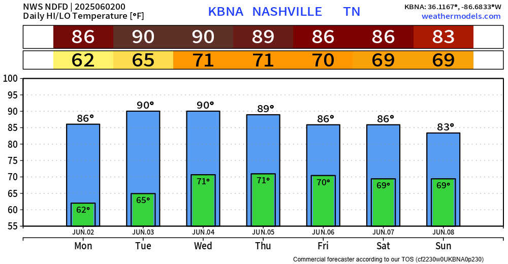
We finally get some rain-free days strung together. Monday thru Wednesday all look dry, but the drawback is we’ll be warming up.
Tuesday thru Thursday all have the chance the chance to break our sub 90° streak this year. Which is something that I think we would all be okay with continuing, but 90s are inevitable.
Our dry streak will end just in time for the CMA Fest…
“Those attending outdoor events will need to be prepared for heat, humidity, and sun interrupted at times by lightning and heavy downpours” says NWS Nashville.
This looks Wattery-style, with random downpours possible each day Thursday – at least Sunday, most likely in the afternoon and evening. Impossible to nail down timing with this kind of thing. Time to embrace the uncertainty. Good news is, doesn’t look like any organized severe threats. Stay connected for updates!
Categories: Featured Blog