
Note: NOAA Weather Radios will be down for today due to maintenance. This means it will not go off if a warning is issued for you. Have other ways to receive warnings if they are issued such as the Wireless Emergency Alerts on your phone, mobile apps. Do not rely on sirens as a way to get warnings, as they are only meant to be heard outdoors.
Storms moving thru this morning might be strong, maybe briefly severe – but should behave for the most part. No tornado worries with this first round. We’ll be tweeting updates as needed on all our socials.
Our main threat will arrive sometime this afternoon/evening.
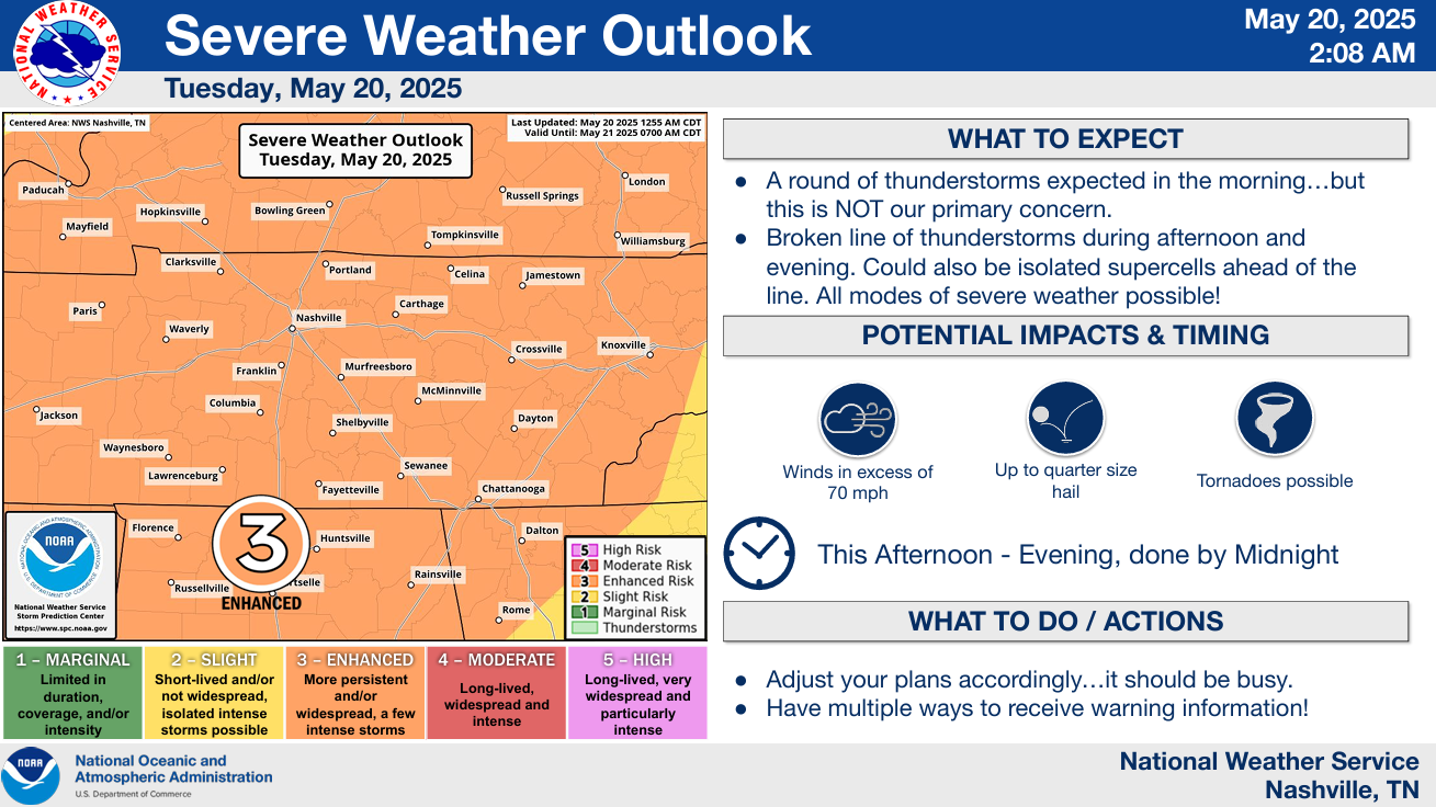
Both of our counties have been outlooked with the following probabilities of ‘x’ within 25 miles:
- 45% chance of damaging straight-line winds (58 mph+)
- 15% chance of severe hail (1″+)
- 10% chance of a tornado (one or two could be strong, EF2+)
The intensity of our main round will depend mostly on how much our atmosphere can destabilize and regroup after this morning round. The less time we get between the two rounds, the better. The morning round of storms was expected, the million-dollar question will be how much time we get to destabilize.
Another thing to watch will be the mode of storms we get. If supercells are able to form and maintain themselves, then we would be looking at all hazards possible. If the storms arrive in a line, then damaging straight-line winds would be the main threat, although a tornado or hail could still not be ruled out.
The main timeframe for severe weather potential appears to be 2p – 8p. It’s hard to get any more specific than that due to the potential scattered, random nature of cells.
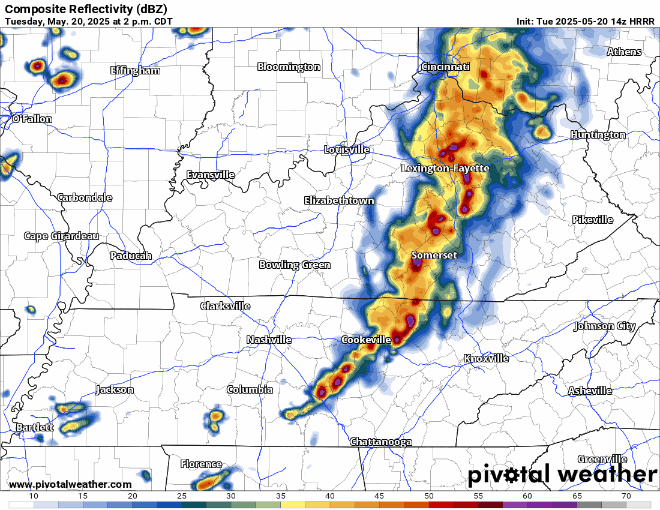
While the radar won’t look exactly like this, the HRRR model gives a guess:
Think AC/DC goers should (knock on wood) be good to commence head-banging after 8/9p. Traveling to stadium might be the challenge. Stay connected for updates, don’t get caught driving/walking in a storm.
Stay connected for updates. It will soon be time to stop looking at models and turn towards observations and the radar. We’ll be sending updates out on all of our socials as needed and will go live on YouTube if a warning is issued for any portion of our two counties.
Have multiple ways to receive warnings (do not count on your NOAA Weather Radio today!), know where your safe place is if a warning is issued for you, know where you are on a map, and tell a friend to tell a friend. Good info on what to do can be found here on our website: What To Do: Tornado Watch vs. Warning | Nashville Severe Weather
Dry and cooler Wednesday thru Friday, with rain chances maybe Saturday or Sunday. More on that after we get past today.
Categories: Featured Blog