
Besides the low chance (~10-15%) of a quick shower Thursday and/or Friday afternoon, we have a dry + warm remainder of the work week.
Turning our attention to the weekend – not to be mistaken for The Weeknd.
Showers and maybe some non-severe storms will be possible during the day on Saturday. Looks like the “highest” rain chances will be Saturday afternoon and evening. Not sure if this will be a washout, as rainfall totals look ~0.5 – 1″. Have a backup plan if you have outdoor plans on Saturday! Specific timing will become evident over the next couple of days.
Onto our main focus, Sunday.
“This setup is conducive for severe weather, which warrants the day 5 SPC [Storm Prediction Center] highlight, but questions till remain on exact impacts and timing for middle Tennessee” – says NWS Nashville.
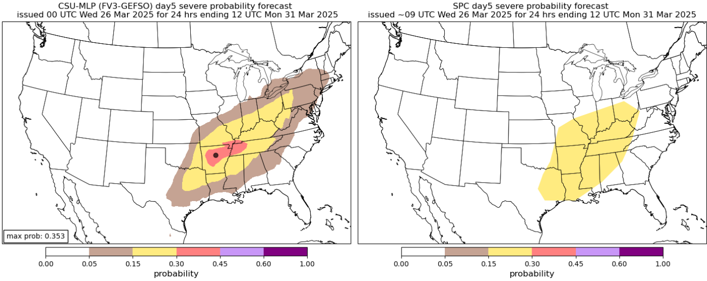
The map on the right is what you are used to seeing – the official outlook from the Storm Prediction Center. This still has us well within the 15% probability of seeing severe weather within 25 miles on Sunday.
The map on the left might be new to you, or you may have seen it going around social media before. This is from the Colorado State Machine-Learning Probabilities Prediction (CSU MLP). While this is unofficial, it is still a respected, useful tool.
This particular run of the CSU MLP generally agrees with the SPC, but it does paint a localized area of higher probs (<30%) to our west, for parts of West TN and Arkansas. It’s also worth noting this has changed several times over the past several days, and probably will a few more times. Just something to watch, along with the official outlook from the SPC.
Models are still in general agreement that ingredients needed for strong to severe weather will all be present, but lots of the smaller details have yet to be worked out. Exact timing, severity, and impacts are still unknown.
For now, stay connected for updates, as things will likely change some between now and then.
Beginning of next week looks cooler + dry starting Monday.
Categories: Featured Blog