
Update as of 11:15 am:
Previous Update from 10:15 am: Overall, the forecast remains on track. We are still looking at two possible rounds of severe weather. While both still have some uncertainty, both rounds are well-worth watching. Continue to stay connected for updates.
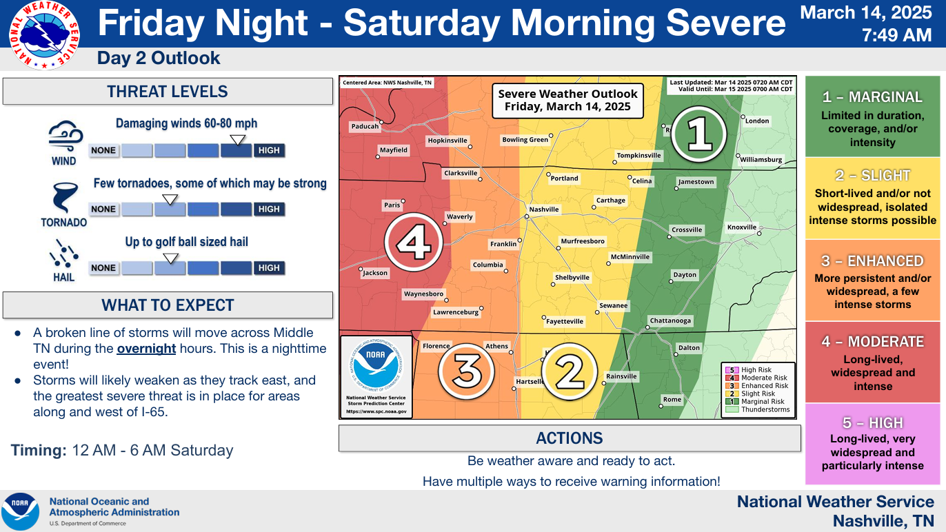
Round One: Friday Night into Early Saturday Morning
Risks:
Probabilities from the SPC remain unchanged from yesterday for our two counties. Probabilities are for ‘x’ occurring within 25 miles of any given location.
- 15% chance of damaging straight-line winds (58mph+)
- 15% chance of severe hail (1″+ in diameter)
- West of I-65 there is a 10% chance of a tornado (which could be strong, EF2+), East of I-65 there is a 5% chance
Generally speaking, the severe threat is higher W of 65 compared to E of 65, but no matter where you are, you need to stay weather aware. Storms don’t care about lines or interstates!
Timing:
Thinking on timing also remains the same – although this is subject to change!
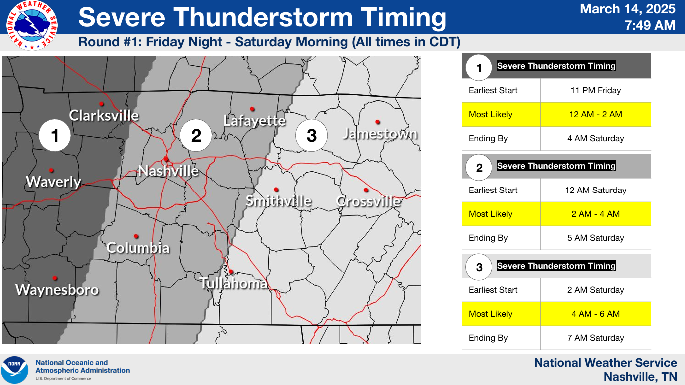
Broad timeframe for our severe weather potential will be from midnight to 5a Saturday, with the most likely timing being between 2a – 4a.
Uncertainties:
NWS Nashville still thinks this is a “boom” or “bust” event – and models agree.
There is expected to be a “cap” in place – which is a layer of warm, stable air aloft. If there is enough forcing and storms are able to break through the “cap” then severe storms will certainly be possible. There is a possibility that the ‘cap’ is too strong, and storms are unable to ever get going – which would be ideal.
Additionally, some new model data thinks the majority of the CAPE (storm fuel) and other severe weather ingredients don’t quite make it to the I-65 corridor, which would help lessen the severe threat.
Models:
Models continue to flip-flop on whether or not we see the “boom” or “bust” situation play out.
The latest HRRR model thinks we are spared from the majority of the severe threat, keeping the worst of the storms out to our west. This is just one run of one model, and while this is certainly a plausible solution, there are other models that have the “boom” scenario.
While I am sure we’d all be totally okay with this scenario playing out – we need to prepare for the “boom” event, especially considering this will be a nighttime event.
Have a way to wake up if a warning is issued for you. Do *not* rely on sirens to wake you up.
NOAA Weather Radio, the Wireless Emergency Alerts on your phone (make sure they are turned ON), wake-me-up app (such as StormWatch+) are all good ways to receive warnings.
It’s also a good time to refresh yourself on your safety plan. Know where to go if a warning is issued for you!

We’ll be up watching the storms and will go live on our YouTube channel if a warning is issued for any part of our two counties.
Round Two: Saturday Afternoon and Evening
While our severe threat is again conditional on a few things, Saturday has the potential to be an impactful day.
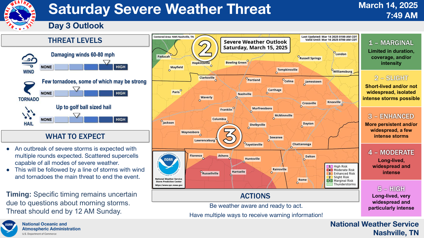
Risks:
The Storm Prediction Center has our counties outlooked with the following probabilities for ‘x’ occurring within 25 miles of any given location:
- 30% chance of damaging straight-line winds (some gusts could be hurricane-force, 74mph+)
- 30% chance of severe hail (could be up to 2″ in diameter)
- 10% chance of a tornado (could be strong, EF2+)
While the threat is higher for folks in Mississippi and Alabama, this round certainly has our attention.
Timing:
Timing is a bit tricky for this round, as models don’t have the best grasp on how things will unfold.
Overall, think the main threat for severe weather would be sometime Saturday afternoon and evening.
Most models show some sort of showers/storms lifting north thru our area during the mid-morning hours on Saturday. While these could still be strong, doesn’t look like this would be our “main event”.
Uncertainties:
There is a good bit of uncertainty on how the morning round of storms plays out. Do storms stick around for a while and help prevent our atmosphere from destabilizing? How far north does the warm front get?
If we stay north of the warm front = good news. This would keep the majority of the severe storm ingredients to our south, reducing (but not entirely eliminating) our chances for severe weather.
If the warm front manages to get north of us, our severe threat would be more likely to materialize.
These are factors that unfortunately all dependent on small-scale, mesoscale features that won’t be realized until the day of. All the more reason to stay connected to the forecast!
Models:
Models should be taken as guidance, not gospel. They are useful tools but rarely exactly right.
I think the latest HRRR model shows a reasonable solution to how Saturday could unfold. Some models somewhat agree, some are different.
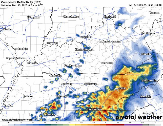
The HRRR model (above) shows those mid-morning showers/storms lifting north, then some individual cells/clusters during the early afternoon, followed by a line of storms sometime in the evening.
If this plays out, the cells in the afternoon would likely carry the greatest threat for severe weather, especially if the warm front is able to get north of us.
This is all the latest data we have as of Friday morning. New data will continue to come in and confidence will increase.
Please stay weather aware and connected now thru Saturday evening. Thinking on timing, threats, can all change between now and then.
Here is a link on a refresher for severe storm terminology & what to do: What To Do: Tornado Watch vs. Warning | Nashville Severe Weather
Traveling and/or have interest in other areas?
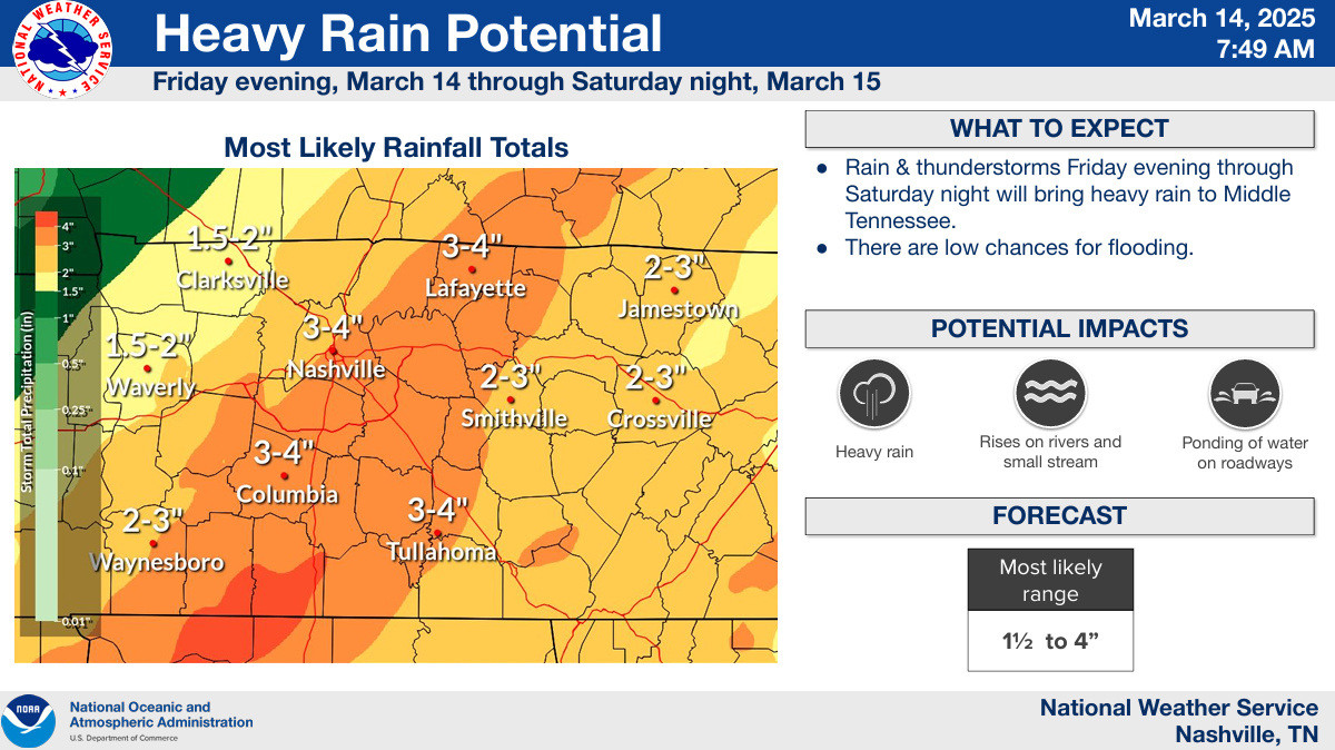
While flooding isn’t the main threat, latest model guidance has bumped up our forecasted rainfall totals to 2-4″. Widespread flooding issues are not expected, but some minor flooding in low-lying areas is possible. Turn around, don’t drown.
We’ll have a new blog out later this afternoon/evening with additional updates with the latest data – along with posts on all of our socials.
All the activity will be gone by Sunday AM. Seasonal temps + dry to start next week.
Categories: Featured Blog