
Headlines:
- 2 – 4 inches of rain on Saturday could lead to flash flooding
- Rivers/creeks may rise above flood level
- All modes of severe weather possible Saturday evening/night
- Winter weather a possibility mid next week
Heavy rain is still expected on Saturday, potentially lingering into early Sunday. Our rainfall totals have come down a tad due to the axis of heaviest rain inching to the NW. Regardless, we still could deal with some flooding issues.
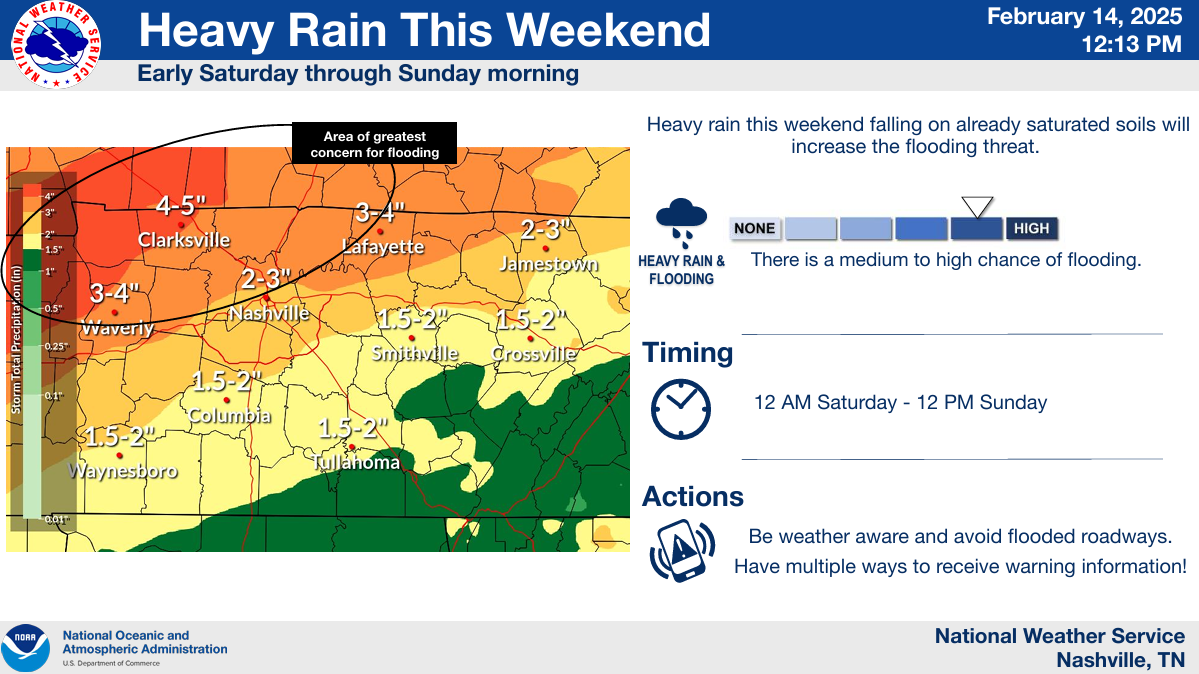
While models are in fairly good agreement that the heaviest rain will end up being to our northwest, this could change, and we’ll keep an eye on it.
2 – 4″ of rain can still cause flooding problems, especially with our already saturated grounds. Our chance of flash flooding occurring within 25 miles is still at least 40%, per WPC.
The latest river level forecasts are included in this thread here ⬇️⬇️
We also still have our severe weather threat to deal with:
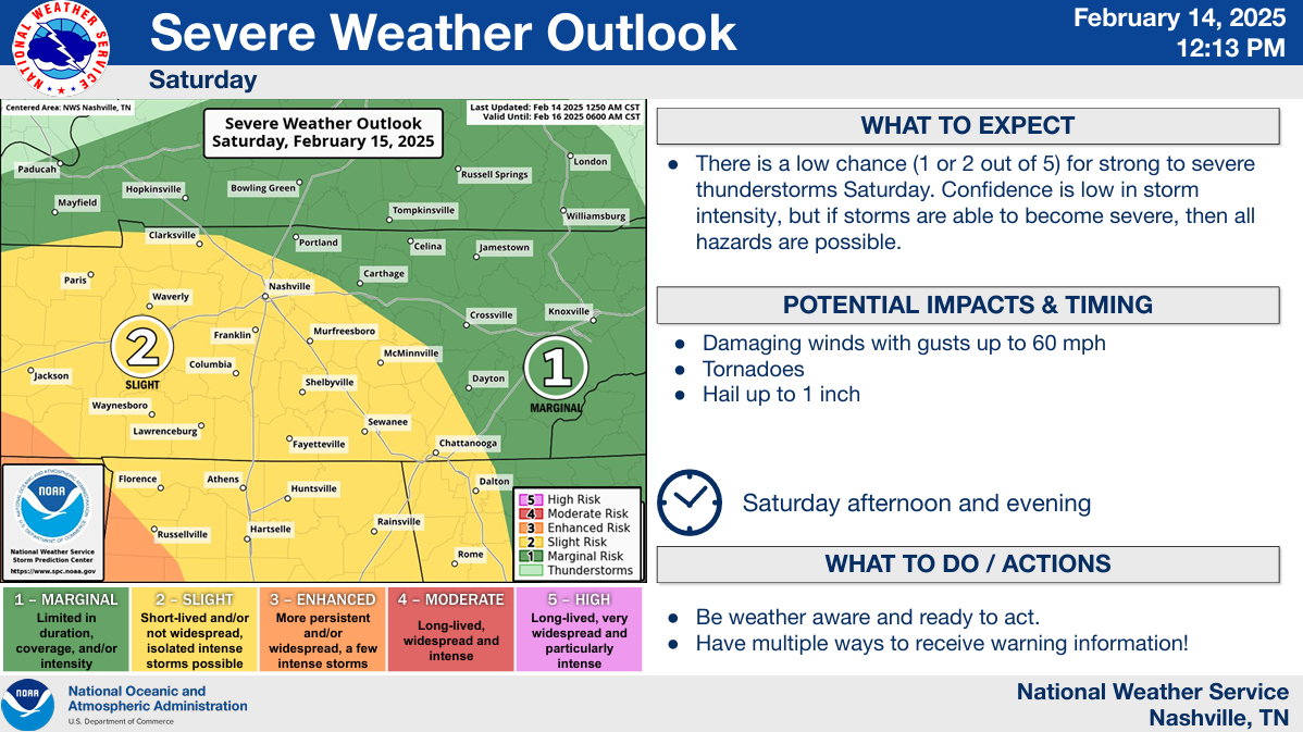
SPC outlooked us with a:
- 15% chance of damaging straight-line winds (58mph+)
- 5% chance of a tornado
- 5% chance of severe hail (1″+)
(all probabilities for ‘x’ occurring within 25 miles of any location)
Higher chances to our southwest.
Timing (subject to change – check back for updates!):
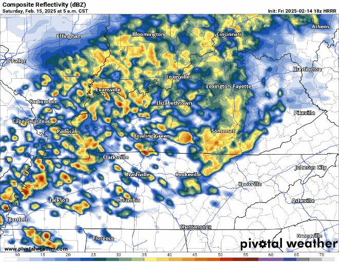
Saturday morning to lunchtime:
- On/off moderate to heavy rain
- Flash flooding and creek rises possible
- No severe weather expected (with this round)
Saturday afternoon to early evening:
- We should get a break from the rain during this time
- Although unlikely, it is possible that cells form ahead of the main line – this will have to be watched
Saturday evening into Saturday night:
- A line of heavy rain will move thru, most likely ETA: 8p to midnight
- Severe weather will be possible during this time – damaging straight-line winds the main threat
- A tornado, severe hail cannot be ruled out
- Flash flooding will also be possible, along with rises in creeks/rivers
Rain should be gone by sunrise Sunday.
The main rivers (Cumberland, Harpeth, etc.) will slowly rise thru the beginning of the next week as all the water drains.
With the severe threat lingering into the overnight hours – be sure to have a way to wake up in case a warning is issued for you. NOAA Weather Radio, wake-me-up app (such as StormWatch+), the Wireless Emergency Alerts on your mobile device – all good resources. Do not rely on sirens to wake you up.
Changes to the forecast are still possible – stay connected for any updates! We’ll be posting on all our socials and will go live on our YouTube channel if any part of our two counties is under a warning.
Winter returns next week – temperatures will be below average for the majority of the time.
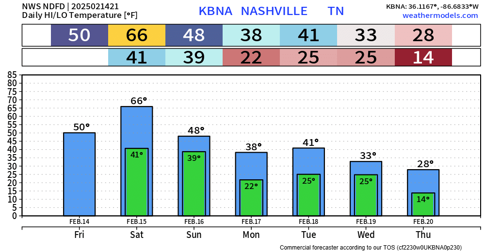
While our focus is still on our flooding/severe weather threat – chances of accumulating snow on Wednesday are slowly increasing. Still far away from any guarantees.
A lot of details still to be worked out – but right now, indications are that a low-pressure system will pass to our south, and with cold air in place and just enough moisture – we could see some snow. A lot can (probably will) change – more specifics on this after Saturday.
Categories: Featured Blog