
Some light showers possible tomorrow (Tuesday) during the AM hours, but these are expected to be few and far between and mostly staying to our north – HRRR model gives its best guess below.

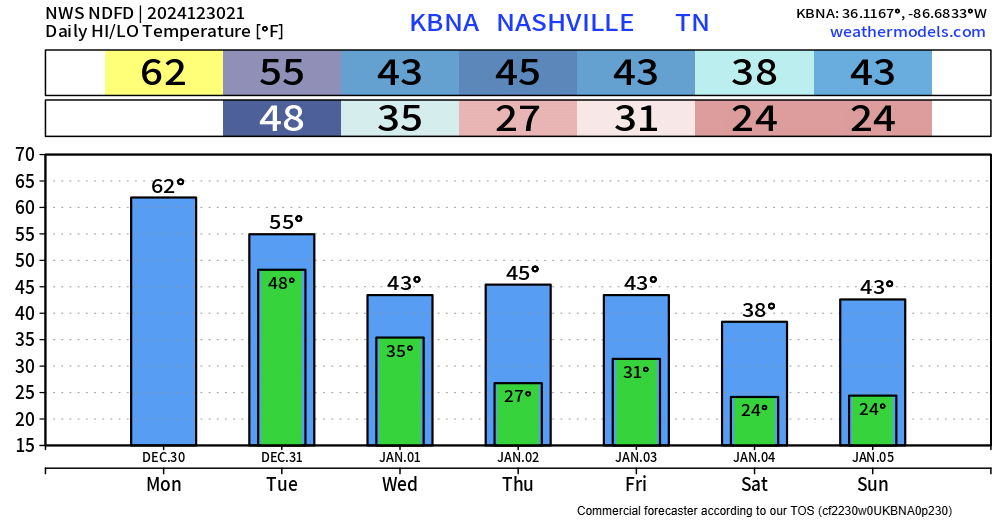
Temperatures Tuesday afternoon will be in the low 50s but will fall to the low 40s with a decent NW breeze overnight. If headed out for New Year celebrations, layers will be your friend.
We’ll start 2025 dry with near-average temperatures for the first several days. A few of us could see some flurries on Wednesday (NYD), but those are expected to splat/melt.
Our overall pattern is expected to change as we get into January.
What is almost a guarantee at this point will be temperatures getting below average.
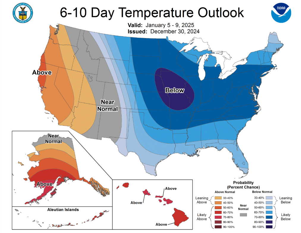
Below average temperatures are favored in the 6 – 10 day range (Jan 5 – 9)…
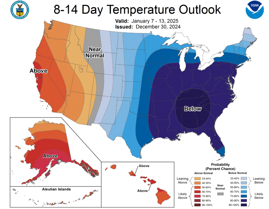
…and especially in the 8 – 14 day range (Jan 7 – 13).
Too soon to tell exactly how far below average temps get but now is as good of a time as ever to start thinking about preparing for dangerously cold temperatures and winterizing your home.

Cold weather always raises questions about sn*w.
Our first *chance* at any winter weather would be brought by a system that is expected to arrive sometime early next week.
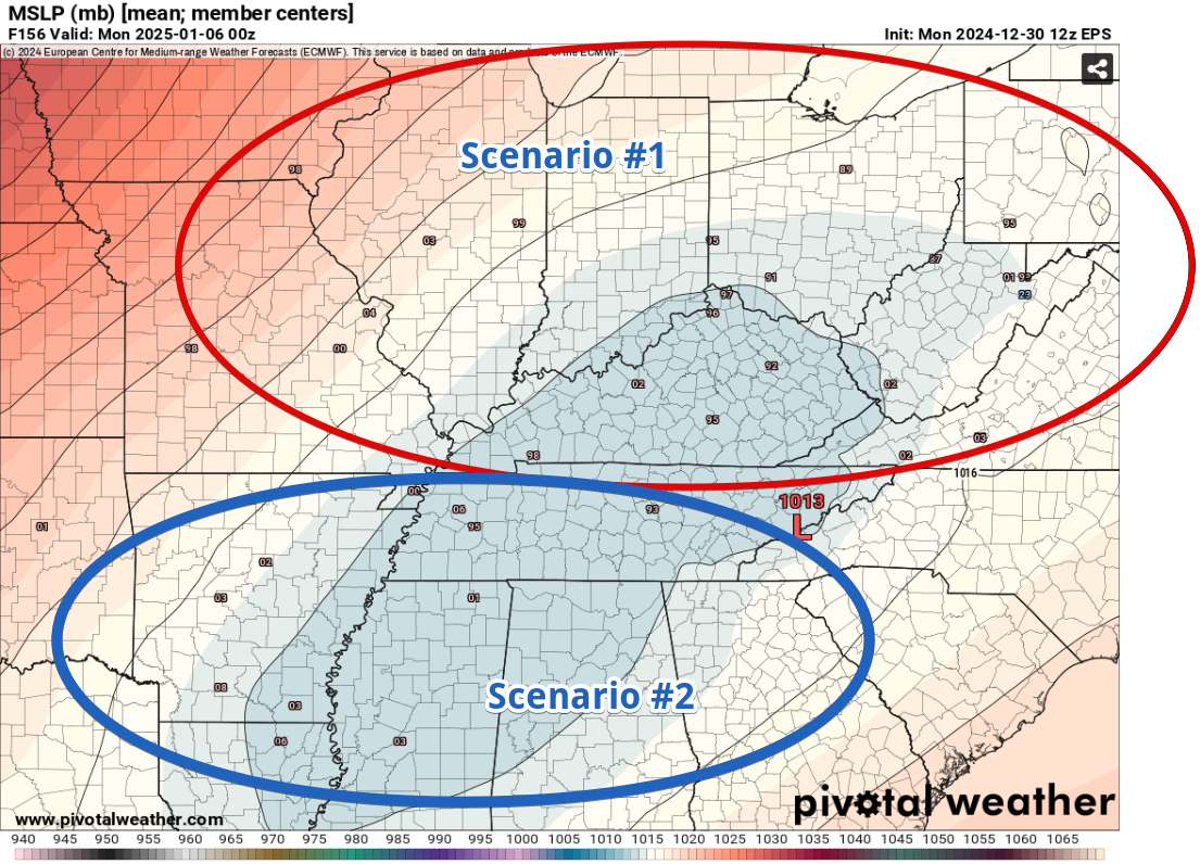
A low-pressure system is expected to make its way across the Plains and go somewhere in the Eastern US. Where exactly it tracks will greatly influence on the type of precipitation we get from it.
This graphic from NWS Nashville sums it up fairly well.
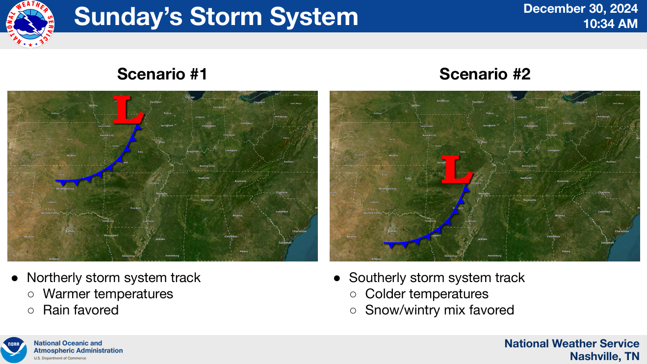
Scenario #1 indicates that the low-pressure system would stay north of us, keeping us on the warm side of things – therefore the precipitation would be stay liquid.
Scenario #2 shows the low-pressure system tracking over/south of us, bringing in colder air and making winter weather a possibility.
Taking a look at the different ensembles, we can get a glimpse of what track may be more favored.
The tiny numbers on the map indicate where the different members of the ensemble think the center of low-pressure will be on Sunday evening.
The Euro ensemble (below) shows a pretty even split between the different ensemble members, about half showing scenario #1 and the other half showing scenario #2.
The GFS ensemble shows the majority of the members favoring Scenario #1, however there has been a recent shift southward.
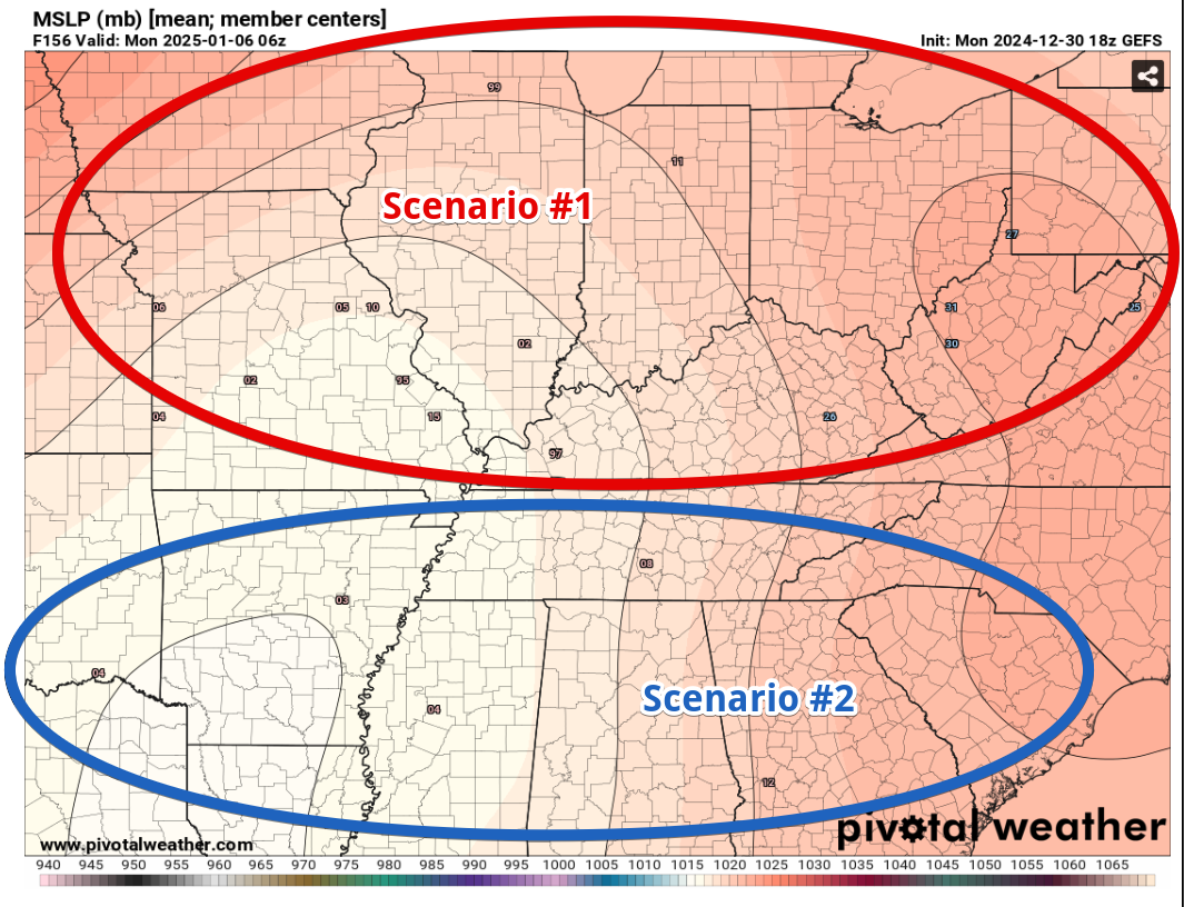
This will be something to watch over the next several days, do the ensembles trend more north or south? How strong will the system be? Will it be faster or slower? With this being 7+ days out, there is no definite answer right now. And if someone says they know for sure – they are lying.
We’ll keep you updated with all the trends and signs.
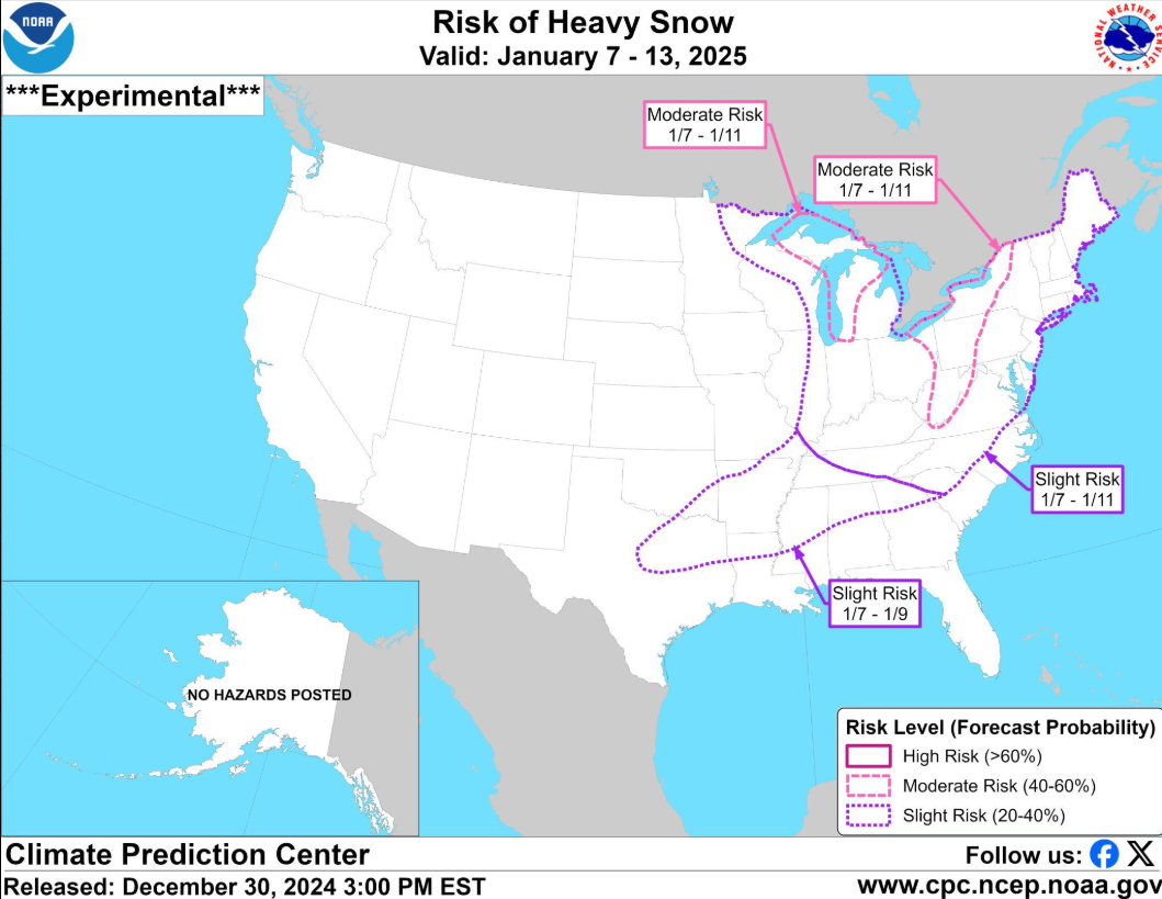
And if this is a swing and a miss on any winter weather, it doesn’t look like this will be our only chance in the next 2 weeks.
The CPC has outlooked us with a 20 – 40% chance of “Heavy Snow” from 1/7 – 1/11. There is no exact definition for what counts as “heavy snow.” Around here, it doesn’t take much for impacts (especially considering how people start to drive when it does). This will be something to watch, but this is far from any guarantee.
Categories: Featured Blog