
Most of the thinking regarding tonight’s relatively low chance for a strong to severe storm remains the same, however the main timeframe for severe weather has changed.
Timing (Still Subject to Change!):
Our timeframe for strong to severe storms looks to be 5p – 2a.
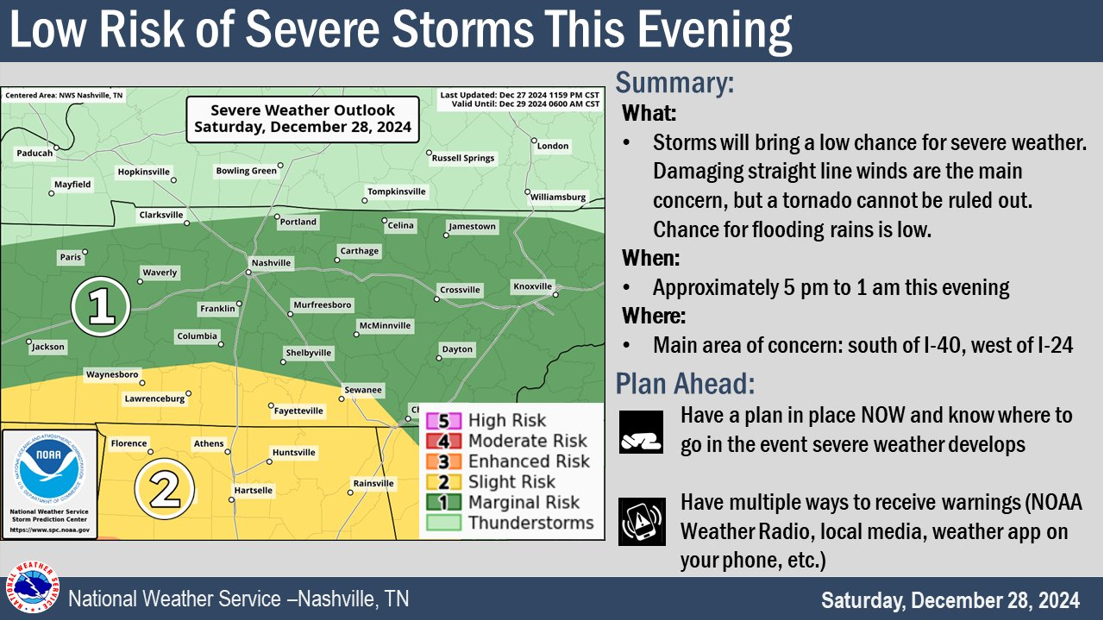
This is a wide timeframe, yes. It appears that our storms will come in two main waves, with the second wave (the main line) being the main suspect for our low chance for strong to severe storms.
The first round of storms will likely arrive in the late afternoon/early evening. I think maybe we could see a few thunderstorms with this, but I think our chance of seeing any severe stuff with this is very low.
The second round of storms looks to arrive late tonight, sometime around 10p – 1a. It appears that this will be our “main show” although our severe threat is relatively low.
Hazards:
Our main threat will be damaging straight-line winds and minor flooding. Although a tornado or two cannot be ruled out.
The Storm Prediction Center has us outlooked with:
– a 5 – 14% chance of damaging straight-line winds within 25 miles
– a 2 – 4% chance of a tornado within 25 miles
– we are not included in any probabilities for hail
Additionally, we also have a 15 – 39% chance of flash flooding within 25 miles.
Data/Thoughts:
The HRRR model (below) shows how this might play out. Likely won’t look exactly like this but can give a general idea.

It shows fairly well the two different rounds of storms, with the main line of storms coming thru around 11p – midnight.
It’s important to note that at the time of the “main line” moving thru, the majority of models show basically zero surface CAPE (storm fuel). This would virtually shut the door on any tornado potential, leaving us with some heavy rain and gusty winds.
This could change, and we’ll be watching closely. We’ll be posting updates as needed on all of our socials throughout the event (X/IG/Threads/BlueSky). *If* a warning is issued for either of our counties, we’ll go live on our YouTube channel.
With the (low) threat continuing into the overnight hours, it’s important to have multiple ways to wake up if a warning is issued for you. Whether it’s a NOAA Weather Radio, the Wireless Emergency Alerts on your phone (make sure they are on!), and/or a wake-me-up app on your phone (such as StormWatch+) – the more, the merrier.

No need to sound the panic alarms, but it’s important to stay weather aware. These high shear/low to no CAPE events are often not much, but they can over-preform. Have multiple ways to receive information, stay connected and have a plan.
The much higher severe weather threat lies well to our south in Louisiana, Mississippi and Alabama. If you have friends/fam down there, make sure to give them a shout.
Next Week/NYE
A few lingering showers on Sunday, most likely in the morning into the afternoon, will be possible – but these will be scattered and no big deal.
Monday looks dry with showers returning to the forecast on NYE (Tuesday) during the morning but should be gone in plenty of time for any NYE celebrations. More specifics on this tomorrow.
Cooler air will come in along with 2025.
Categories: Featured Blog