


Quiet and dry rest of the evening.
Things quickly change tomorrow morning as a cluster of rain/storms moves in.
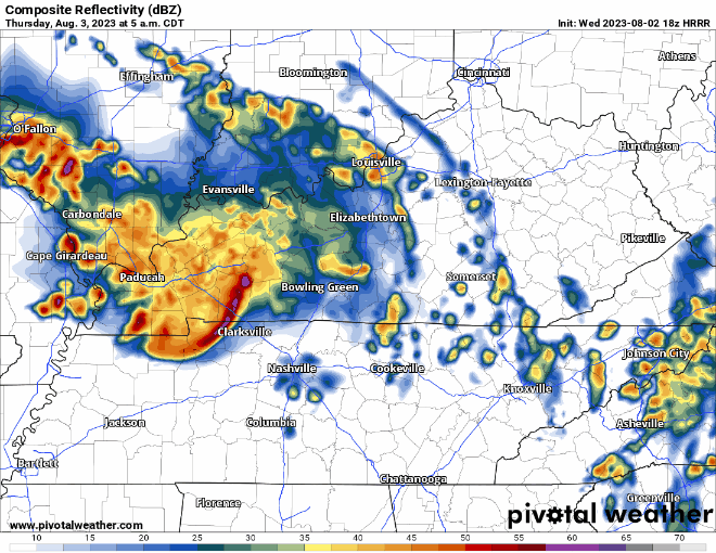
HRRR model (above) thinks heavy rain, along with the potential for gusty winds moves in just in time for AM rush hour…

The Storm Prediction Center has us outlooked with a 5% chance of damaging straight-line winds within 25 miles. We are not included in any hail or tornado probabilities.
HRRR model thinks a majority of the rain is gone by Thursday afternoon, but not before dumping a good amount of rain. Rollyball sports not looking good.
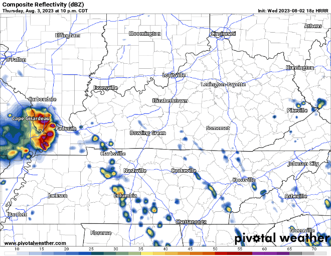
HRRR model shows additional storms moving thru overnight Thursday around midnight. These could contain damaging straight-line winds, along with lightning and heavy rain. May want to plan to have additional guest in the bed.
More on/off showers possible Friday. Timing unclear.

A couple inches of rain possible thru Friday. This should be spread out enough to avoid widespread flooding issues, but a few isolated spots could experience some flash flooding.
When you aren’t dealing with rain, heat + humidity returns Friday – Sunday, with heat index values up to 105° possible.
Additional rain/storms possible Saturday and Sunday. Timing is fuzzy still, but for now best chances look like afternoon/evening. No severe weather currently in the forecast, but some heavy rain and gusty winds are possible. Not the best forecast for the Grand Prix.
Rain chances relax a bit early next week.
Quick References:
Weather changes constantly.
Follow @NashSevereWx on Twitter for any changes to this forecast.
Live coverage during tornado and severe thunderstorm warnings:

Look good.
Support the mission.

We are 100% community supported. No ads. No subscription fees. Keep it free for everyone.


 Log In To Facebook To Comment