


9PM UPDATE
Things have changed a little since this morning. Both counties will be under a Flood Watch from midnight tonight until noon Thursday. 1-3″ of additional rain is possible, with a few pockets containing heavier rain possible. Rain may begin as early as the wee-hours of Thursday morning and continue until Thursday afternoon.
Along with the potential for flash flooding, severe weather is also possible.
The Storm Prediction Center has outlooked us with a:
- 5% chance of damaging straight-line winds and/or severe hail within 25 miles
- 2% chance of a tornado within 25 miles
Everyone should stay connected, especially if you live in a flood-prone area. Have a way to wake-up in case a warning is issued for you.
We should clear out Thursday evening, with more rain/storm chances returning Friday afternoon.
*Below is the blog from this morning, some info may be out-of-date*
The worst of the rainfall has been to our northwest. However a few inches of rain are still possible, and the Flood Watch is still in effect until noon.
HRRR model (above) still shows a few hours of heavier rain. If you live in a flood-prone area you still need to be paying attention, flash flooding can occur quickly. You can check local river/creek levels here nashvillesevereweather.com/rivercreek-flood-stages/
Turn around, don’t drown.
Embedded in this heavy rain, severe storms are possible. The Storm Prediction Center has outlooked us with a:
- 15% chance of damaging straight-line winds within 25 miles
- 5% chance of severe hail within 25 miles
- 2% chance of a tornado within 25 miles
Stay connected today. We should dry out by this evening. If you see any flooding, snap a pic if you can, tweet it using #tspotter and include a specific location like cross streets.
Unfortunately, rain and storm chances continue tomorrow.
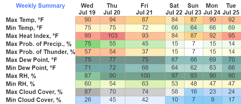
The HRRR model thinks we stay dry, which would be awesome, but it also could be wrong. Some storms may be strong to severe, timing looks to be in the morning if we do see anything. If we don’t see any rain, the heat will be noticeable with heat index values around 100°.
One more day of rain/storm chances Friday before we finally dry out and even “cool down” a little to the mid to upper 80’s this weekend.
Quick References:
Weather changes constantly.
Follow @NashSevereWx on Twitter for any changes to this forecast.
Live coverage during tornado and severe thunderstorm warnings:

Look good.
Support the mission.

We are 100% community supported. No ads. No subscription fees. Keep it free for everyone.


 Log In To Facebook To Comment