


Quick Summary: Next 48 Hours
Temps
Rain
Afternoon Update!
If you don’t like uncertainty, you should probably stop reading now.
All eyes are on the temperature and precipitation type for early tomorrow morning.
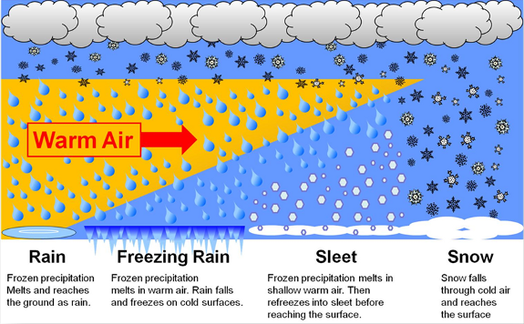
NWS-Nashville thinks the wintry precipitation shenanigans will begin around 3 AM. As the rain falls, the dry air will zap some of the rain, but when that happens, the air gets colder (this is called evaporative cooling). Once the dry air is done eating (and the air is saturated), the remaining precip can begin to do its thing.
That thing will be anything from a cold rain, to freezing rain, to sleet, and maybe even a little snow, but the best chance for snow will be closer to the Kentucky border.
Some points I’ve taken from NWS-Nashville’s afternoon forecast discussion:
- No ice accumulations are expected at this time because surface temps will remain relatively warm and freezing rain may only occur for a short period of time.
- Keep in mind we are, as usual, right on the freezing line. A wobble here or there will make all the difference between no impact and some impact. This will therefore be monitored very closely late tonight and early tomorrow morning.
- Based on current road temperatures, it’s unlikely that overnight roadway temperatures will drop enough for busy highways to be impacted, but less traveled roads and bridges could see some slick spots during the morning commute Thursday morning.
- After the sun comes up, expect temperatures to warm above freezing, and melting anything slippery that may be trying to hold on.
If you’ve been following us on Twitter @NashSevereWx, you’ll notice the HRRR and RAP (our two short-range, higher resolution models) have been keeping the wintry temperature profiles juuust north of us near the KY border. If those models verify, we’ll be fine in the morning.

But, it’s really close.
Consult multiple reliable weather sources throughout the evening. We probably will not do another big update here on the website; we’ll be on Twitter!
Finally, if you see any slick spots, sleet, snow, or freezing rain, let NWS-Nashville know by tweeting it with the hashtag #tSpotter.
Thanks to @EditingNLayout for this expression of snow-lover consternation:

Thursday Afternoon – High 41°
During the late afternoon into the early evening, we will become rain free and remain mostly cloudy for the rest of the night.
Friday – Rain…Maybe Snow Late? – Wake Up 31°, High 47°
We will have a slight chance of rain beginning at noon as a low pressure disturbance originating out of the Gulf of Mexico makes its way towards Middle Tennessee.
Rain will become likely overnight into Saturday morning as the disturbance moves overhead. This morning, we didn’t think this would be a snow event.

Right now, we aren’t so sure. Think about it this way: right now, we are 12 hours away from a potential rain/snow/sleet/freezing rain event, and we aren’t sure what we’ll see, so it seems a little silly to try to parse the information right now for late Friday night into early Saturday morning. My gut says it’ll be just a rain event, but, as we wrote this morning, we really don’t know. It’s that close a call.
Dreaming of a White Christmas?
This morning, we wrote:
For example, the GFS model has, on Christmas Eve morning, temps at 5,000 feet well below freezing with lingering precip:

But the surface temps are forecast to be 34°, so that would mean a melting snowfall.
This afternoon, NWS-Nashville wrote: “A surface front will likely move into Middle Tennessee [Christmas Eve morning], gradually increasing probability of precipitation and perhaps even producing some snow across parts of Middle Tennessee early Christmas even and early Christmas morning as an extensive area of occluded front moisture filters across the mid state well after the passage of the cold front.”
Well then.
Still, remember:
Will there be a White Christmas? Probably not.
Do we really know? No.
Should you believe a forecast model 7 days away? No. You should not. Thou shalt not believe a forecast weather model 7 days away. Use models for guidance, not gospel.
Christmas will signal a shift to colder temps. Rather than upper 40°s/low 50°s highs with wee hour temps hovering around freezing, we’ll see highs in the upper 30°s with lows in the 20°s after Christmas:

This website is part of the ongoing conversation on Twitter @NashSevereWx on Twitter. You can find that here.
 Log In To Facebook To Comment