Heavy Rain, Low-End Severe Threat Tonight thru Wednesday Mid-Morning
Tuesday, November 3, 2026 · Elan
An abnormally warm November day is underway, with highs on the way to near 80°. Our daily record high is 83° and while I’d be surprised if we broke it, I think we could get close. Lots of warm air streaming in thanks to some pretty strong gusts from the S.
During the day we’ll be dry, this will be a good time to go ahead and put up those Halloween decorations, along with making sure your gutters and nearby storm drains are clear of leaves.
Later this afternoon and evening, we’ll begin to look at the radar and watch our highly anticipated line of showers/storms move our way.
In summary, we are still expecting rain to arrive late tonight, continuing thru Wednesday mid-morning/lunch-ish. Generally, rainfall amounts will end up near 1.5 – 2″, although I won’t be shocked if some places saw between 2-3″, especially W of I-65.
The risk of severe weather is low, but not zero. The mid-morning update from the Storm Predicition Center has introduced a 2% chance of a tornado risk for those W of 65, and a 5% chance of damaging straight-line winds for much of our area, both within 25 miles.
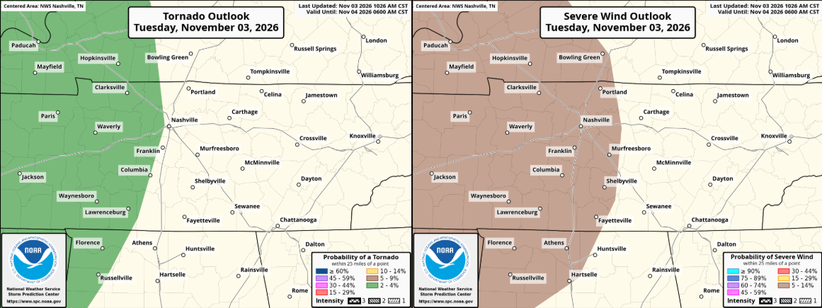
This is our classic, late-season, low-end severe weather set up – with a fairly potent cold front swinging thru, with tons of wind energy available. The limiting factor will be the instability/CAPE (storm fuel), with models expecting very little CAPE available. However, with how much shear we’ll have, it won’t take much instability for a quick weak, spin-up tornado.
The HRRR gives its latest guess on how the radar plays out, although it won’t look exactly like this:

It seems our main window for any severe threat would be the early morning hours of Wednesday morning thru about midday as the showers/storms move out from W to E.
Now is a good time to make sure you have ways to wake up in case a warning is issued for you, not only just for tonight, but we are entering the beginning of our second severe weather season. Whether it’s a NOAA Weather Radio, wake-me-up app, or the Wireless Emergency Alerts on your phone – the more the merrier. Do not rely on sirens to wake you up – they are not meant to be heard indoors.
Also, know where your safe place is. Often times in these set-ups, warnings are issued fast as these circulations spin-up quickly, with not a ton of lead time. Have it already prepared – you will very likely not need it, but it’s better safe than sorry. We have more information here: Nashville Severe Weather – Be Prepared
The risk of flash flooding is also fairly low, but not zero. We should be able to handle most of the rain, but if any of the heavier downpours start to go over the same areas, we could see some quick rises on some creeks/streams, along with ponding on the roads. Regardless, the morning commute Wednesday will not be fun. Allow yourself some extra time.
We’ll be watching how things progress all day and night and will post updates on all of our socials. If we do get a warning, we’ll go live on our YouTube channel – which you can find here: Nashville Severe Weather @NashSevereWx – YouTube
Again, this is a very low-end threat, but also not something to shrug off. Be prepared, not scared! Stay connected.
We’ll begin to dry out and cool off starting Wednesday afternoon. No additional rain chances this week, as we look to our first widespread frost/freeze chances by this weekend.
