Healthy Rainfall Tuesday Night/Wednesday Morning
Monday, November 2, 2026 · Elan
Yesterday’s rainfall was certainly overachieving – which is fantastic news, we’ll take all we can get.
Williamson Co. were the big winners, but pretty much everyone saw at least 0.5″+.

Today will be dry for most, can’t rule out a quick shower – especially for those in Robertson, but these will be no big deal. We’ll gradually clear out, with the sun peeking out more and more as we head towards this afternoon. Too bad our sunset is at 4:50p.
Tuesday *during the day* will be mostly dry and quite warm with highs reaching into the upper 70s, 10°+ above-average for early November. Wouldn’t be shocked if there was a quick shower at some point during the afternoon tho.
Late Tuesday night into the morning hours of Wednesday we’ll watch as a line of heavy showers moves into the area, likely to provide some beneficial rainfall for us.
The HRRR model is mostly in range, and is a bit faster with the ETA compared to some of the other models, but I’ll still show it’s guesstimate:
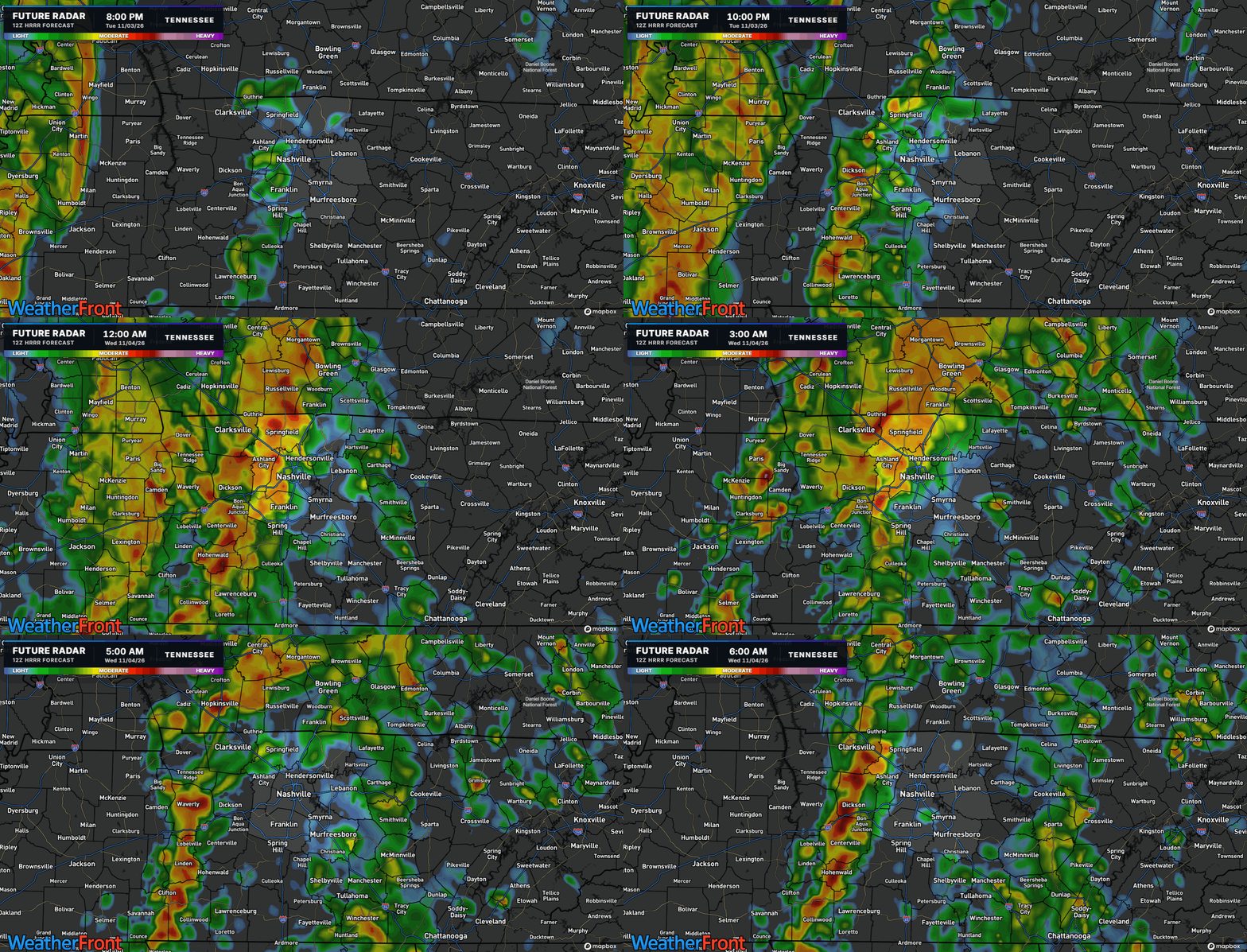
It seems most of the rainfall will fall between midnight and rush hour on Wednesday morning – yikes. Be prepared for your commute to be a little longer than normal.
The good news is that no severe weather is expected, lightning will even be at a minimum thanks to very little to no instability. However, winds aloft will be super strong and some of those will be able to mix down to the surface in the heavier showers, so gusts up to 30-40mph will be possible overnight Tuesday into Wednesday morning. It’ll be a good idea to get those Halloween decorations put up before then.
Rain should begin to taper off by Wednesday lunch/afternoon-ish.
When all is set and done, most will likely see around 1.5″ of rain. While this won’t completely erase our drought, combined with yesterday’s rain – it’s absolutely a step in the right direction. We should be able to avoid flooding concerns with the relatively quick moving line, but we’ll keep an eye on things.

Thursday and beyond into the weekend will be cooler and dry. Temperatures will settle down to around average, even slightly below average. We’ll probably be looking at our first potential for widespread frost by early next week.
