


Current Temps and Radar

Wednesday – Winter Weather Advisory – Wake Up 26°, High 38°
We are under a Winter Weather Advisory, beginning noon Wednesday, lasting until 6 AM Thursday.

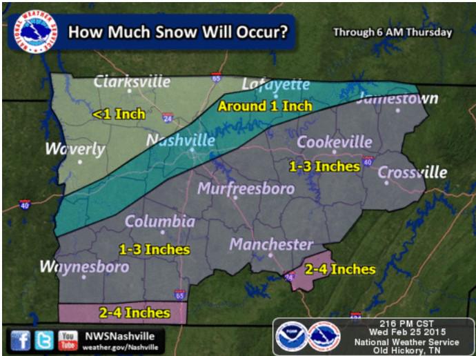
The National Weather Service believes that the majority of Williamson County will accumulate around 1″, maybe more, of snow… With the exception of the very north western portions. Less is expected in Davidson County.
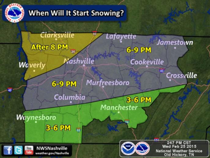
The event should all start between 6 PM and 9 PM:
What do the weather models say about the snow totals?
NAM4 (12z run) has us getting between 1″ and 2″ of snow. Most of the action stays south of Nashville

GFS (latest run, 12z) has Nashville getting a dusting to 1″ of snow. The track of snow is further south.

Euro model (not shown), agrees: 1″.
And then there is the Canadian, the under-performer:

None of the models think that we will see additional snow after midnight. This system will move fast.
Areas south of I 40 and east of I 65 will likely get above an inch, while places north of I 40 and west of I 65 are expecting a dusting.
The weather balloon from 6 AM this morning shows that the entire atmosphere is below freezing and is just waiting on the surge of moisture.

The amount of snow we get will be completely reliant on the track of the disturbance to our south.

Infrared imagery from 9:15 AM shows the disturbance tracking closely along the Louisiana coast. If it stays further south we will have a dusting of snow, but if it begins to track further north we will have above an inch.
Additional updates can be found @NashSevereWx on Twitter, which you can find here for all the latest on this winter storm. Consult multiple reliable weather sources multiple times.
 Log In To Facebook To Comment