


Current Radar
THIS EVENING – SHOWERS & STORMS CONTINUE
We are under a slight risk for severe thunderstorms through early tomorrow morning:
While strong storms are likely to continue for areas inside this brown line, we’re not expecting a severe thunderstorm watch to be issued:
Damaging winds and hail will be of greatest concern with today’s storms:
The tornado risk is practically non-existent:
Here’s NWS Nashville’s threat graphic, which includes flooding:
The flooding risk has been raised a bit today, and will continue to be of concern as more rain arrives through the weekend.
HRRR future radar loop from lunchime to 2 AM shows most — but not all — of the evening rain and storm activity to our south:

However, it doesn’t look like activity will end completely overnight. Lows will remain near 70°.
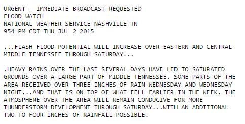
In addition, tonight our NWS office issued a Flash Flood Watch for Davidson County, where an additional 2″ to 4″ of rain is possible through Saturday night.
FRIDAY – Another Day, Another Chance for Rain – Wake Up: 70°, High: 80º
We have a marginal risk for severe thunderstorms tomorrow:
Tomorrow looks similar to today, with showers and storms beginning early and continuing throughout the day. However, we may catch a bit of a break early-on:
But, things will pick up by the afternoon:
If you’re headed to the USMNT game tomorrow evening, things don’t look too bad, according to this model:
We’ll know more as more model runs come out today, but hopefully we’ll catch a break tomorrow evening for the game.
SATURDAY – A Rainy 4th – Wake Up: 67°, High: 80º
Rain chances will continue into Saturday, as the dip in the jet stream over the eastern US will continue to allow disturbances (rainmakers) to move through the Midwest and swing rain/storms our way.
Unfortunately, it looks like we won’t be able to shake this pattern until after this weekend. If you have outdoor plans for the 4th of July, I would start making indoor plans.
Looks like a wet afternoon:
And, a wet evening:
EXTENDED: Wet Weekend Ahead
With so much rain in the short-term and extended forecasts, NWS Nashville issued this statement on flooding concerns:
Remember: Turn Around, Don’t Drown. Take it easy out there!
This website supplements @NashSevereWx on Twitter, which you can find here.
 Log In To Facebook To Comment